Liven up your holidays!
Destination
State your preferences
Guide
Plan your stay
Your account
English
Français
Deutsch
Italiano
Español
Nederlands
Português
Русский
简体中文
日本語
0
0
0
Saint-Gervais
Menu
Tourism
Gastronomy
Outings
Activities
Events
Restaurants
Hotels
Vacation rentals
Bed & breakfasts
Campsites
Holiday insurance
Rental car
Train tickets
Plane tickets
Transfers
Holiday insurance
Holiday insurance
French courses
Romantic weekend
Family weekend
Cheap weekend
Unusual weekend
Find my position
Confirm
Discover
Tourist sites
Gastronomy
Cities & towns
Tourism labels
Themed itineraries
Custom itineraries
Photos
Panoramas
Tourism quiz
Going out
Leisure activities
Outings
Events
Restaurants
Stay
Hotels
Bed & breakfasts
Vacation rentals
Campsites
Travel
Rental car
Train tickets
Plane tickets
Holiday insurance
Information sheets
French courses
Outings
Around Saint-Gervais
Outings in Saint-Gervais
Ideas for walks and hikes in Saint-Gervais
Search
Cancel
27
outings found
Saint-Gervais
Change
Adjust destination
Town centre of Saint-Gervais
Transport - Train station of Bollène-la-Croisière (Bollène)
Information point - Tourist Office of Aiguèze (Aiguèze)
Information point - Tourist Office of Bagnols-sur-Cèze (Bagnols-sur-Cèze)
Information point - Tourist Office of Bollène (Bollène)
Information point - Tourist Office of Goudargues (Goudargues)
Information point - Tourist Office of Méjannes-le-Clap (Méjannes-le-Clap)
Information point - Tourist Office of Orange (Orange)
Information point - Tourist Office of Pont-Saint-Esprit (Pont-Saint-Esprit)
Information point - Tourist Office of Saint-Laurent-des-Arbres (Saint-Laurent-des-Arbres)
Information point - Tourist Office of Saint-Martin-d'Ardèche (Saint-Martin-d'Ardèche)
Leisure centre - Archaeological Museum Léon-Alègre (Bagnols-sur-Cèze)
Leisure centre - Cave of the Madeleine (Saint-Remèze)
Leisure centre - Museum of Orgnac (Orgnac-l'Aven)
Leisure centre - Museum of Sacred Art of the Gard (Pont-Saint-Esprit)
Leisure centre - Racecourse of the Levade (Bollène)
Monument - Cathedral Notre-Dame-de-Nazareth (Orange)
Monument - Chapel Saint-Jean-d'Orgerolles (La Bastide-d'Engras)
Monument - Church Notre-Dame du Val-Romigier (Mornas)
Monument - Church Saint-Michel (Caderousse)
Monument - Church of Saint-Laurent-des-Arbres (Saint-Laurent-des-Arbres)
Monument - Collegiate Church Saint-Martin (Bollène)
Monument - Fortress of Mornas (Mornas)
Monument - Tower Jacques Deuze (Saint-Laurent-des-Arbres)
Monument - Tower of Ribas (Saint-Laurent-des-Arbres)
Performance hall - Cultural Centre Léo Lagrange (Bagnols-sur-Cèze)
Performance hall - Forum de Laudun-l'Ardoise (Laudun-l'Ardoise)
Performance hall - Municipal Theatre of Orange (Orange)
Performance hall - Salle Multiculturelle (Bagnols-sur-Cèze)
Natural site - Natural Area of the Concluses (Lussan)
Sort by distance from starting point
Sort by difficulty
Sort by change in altitude
Sort by duration
Sort by length in kilometres
Filter results
Open map
Outing type
Hike
Cycling itinerary
Horse ride
Other means of transport
Distance from starting point
Less than 10 km
from 10 km to 30 km
More than 30 km
Difficulty
Easy
Intermediate
Athletic
Change in altitude
Less than 200 m
from 200 m to 500 m
from 500 m to 1000 m
More than 1000 m
Duration
Less than 2 h
from 2 h to 4 h
More than 4 h
Kilometres
Less than 5 km
from 5 km to 10 km
from 10 km to 20 km
More than 20 km
Territory
Dauphiné
Drôme-Ardèche
Languedoc-Roussillon
Massif Central
Provence
Filter results
Hide filters
Open map
Hide map
Outings in Saint-Gervais
Outings around Saint-Gervais
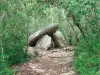
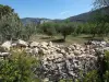
Dolmens walk
6.0
10
Hike in Barjac
Easy
1:45, 8 km (change in altitude 0m)
Amid the woods and scrubland, set off to explore the dolmens in the woods of Barjac. No particular difficulties, gradual inclines.
Located
23 km
away of Saint-Gervais
Favourite
Itinerary
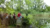
The Hermitage
5.7
25
Hike in Collias
Easy
3:00, 11 km (change in altitude 0m)
The Collias Hermitage (11.5 km - 3 hours) - This shady family walk will lead you to Notre-Dame de Laval Chapel. For the more athletic, it is possible to continue on a loop and descend to the Torte path, the former road to Nimes, which offers…
Located
27 km
away of Saint-Gervais
Favourite
Itinerary
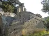
On the trail of the hermit
7.9
14
Hike in Saint-Montan
Intermediate
3:00, 12 km (change in altitude 200m)
Above the medieval village of Saint-Montan, you will walk along a cliff in a very wild environment to Calvary marking the location of the cave where lived in the seventh century a hermit, Saint Montan (its history is evoked in a children's book…
Located
29 km
away of Saint-Gervais
Favourite
Itinerary
Richerenches - Visan - Richerenches
8.0
1
Cycling itinerary in Richerenches
Easy
1:00, 16 km (change in altitude 72m)
Easy, family circuit by bike, VTC or pedestrian. Not recommended in windy conditions strong. Remarkable points of view on the Mont Ventoux and the Lance.
Located
33 km
away of Saint-Gervais
Favourite
Itinerary
Between vines, truffle fields and lavender
8.0
1
Hike in Richerenches
Easy
2:00, 11 km (change in altitude 0m)
2 easy and family circuits along vineyards, truffles and lavender fields. Loop n ° 2: rather recommended for mountain bikes and hybrid bikes (11 km) Loop n ° 3: rather recommended for pedestrians (8.5 km) Attention for loop n ° 2, there is…
Located
33 km
away of Saint-Gervais
Favourite
Itinerary
Pedestrian circuit to explore the village of Richerenches
8.5
2
Village visit in Richerenches
Easy
40 min, 1 km (change in altitude 0m)
Nice circuit and historical discovery of the Templar village.
Located
33 km
away of Saint-Gervais
Favourite
Itinerary
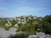
Dentelles de Montmirail Massif
7.7
63
Hike in Gigondas
Easy
2:00, 7 km (change in altitude 200m)
Easy walk for all. You will find a typical Mediterranean plant life and protected plants and animals. Wear a good pair of walking shoes and carry water and a whistle (during the hunting season). Respect nature (remove your waste) and the silence.…
Located
35 km
away of Saint-Gervais
Favourite
Itinerary
7.5
6
Hike in Ruoms
Intermediate
2:40, 8 km (change in altitude 256m)
Located
35 km
away of Saint-Gervais
Favourite
Itinerary
Mine au Bois Dormant Path
5.6
11
Hike in Robiac-Rochessadoule
Intermediate
3:00, 8 km (change in altitude 250m)
This path winds around the Rieusset valley and passes through Rochessadoule, which is part of the municipality of Robiac-Rochessadoule. It is possible to obtain a leaflet presenting the route from Bessèges Tourist Office.
Located
37 km
away of Saint-Gervais
Favourite
Itinerary
Corniche Casteljau
8.0
1
Hike in Casteljau
Easy
1:30, 4 km (change in altitude 388m)
Pretty hiking in the woods Païolive, at any age, mixing ride under oaks and on the limestone plateau. Great view of the Chassezac.
Located
39 km
away of Saint-Gervais
Favourite
Itinerary
Winemaker's Trail
8.1
15
Hike in Lablachère
Easy
2:30, 8 km (change in altitude 80m)
Signposted winemaker's trail departing from the Lablachère wine cooperative. There is a large board presenting the itinerary at the car park. This path will lead you through the vineyards planted on terraces where Chatus, the emblematic grape…
Located
42 km
away of Saint-Gervais
Favourite
Itinerary
Basilica of Our Lady (Notre-Dame) and megalithic bridge
7.8
7
Village visit in Lablachère
Easy
1:15, 5 km (change in altitude 0m)
This pleasant walk will take you from the Basilica of Our Lady of Good Help (Notre-Dame de Bonsecours) to La Jaujon, via the megalithic bridge…
Located
42 km
away of Saint-Gervais
Favourite
Itinerary
Fountains of Pernes
7.7
14
Village visit in Pernes-les-Fontaines
Easy
2:00, 2 km (change in altitude 0m)
Discover the 40 fountains in the village. Some are obvious: Cormoran Fountain, Gigot Fountain, Reboul Fountain, Ange Fountain.... others are more surprising: Font de la Lune... Some will require more patience and perspicacity. A walk for all…
Located
44 km
away of Saint-Gervais
Favourite
Itinerary
Upper Blajoux Valley
6.0
23
Hike in Sanilhac
Easy
1:30, 4 km (change in altitude 100m)
Walk through the chestnut grove along old paved paths, cross the hamlet of Marinier and an old bridge over the Blajoux stream.
Located
46 km
away of Saint-Gervais
Favourite
Itinerary
The lost trails
7.7
9
Hike in Bonnevaux
Intermediate
5:00, 8 km (change in altitude 400m)
Very beautiful walk, part of which follows an old sheep trail. Wooded sections, clear views from the summit (over Mount Lozère, the Vivarais Mountains, the Rhone valley and Mount Ventoux), valley floor with schist walls and chestnut trees.
Located
48 km
away of Saint-Gervais
Favourite
Itinerary
Around the Comtat Venaissin
7.3
3
Village visit in La Roque-sur-Pernes
Easy
2:00, 6 km (change in altitude 0m)
Visit to three typical Provencal country villages.
Located
48 km
away of Saint-Gervais
Favourite
Itinerary
From the Spring to the Venice of Provence
6.4
17
Cycling itinerary in L'Isle-sur-la-Sorgue
Easy
2:00, 21 km (change in altitude 0m)
From the Spring to the Venice of Provence: Distance: 21 km - Time required: 2 hours. The major sites of the Sorgue await you during this outing, the watershed, the abyss and the canals which wind their way through the fields. A whole world is…
Located
49 km
away of Saint-Gervais
Favourite
Itinerary
Olive Tree Trail
8.5
2
Hike in Nyons
Easy
1:30, 4 km (change in altitude 384m)
Discover the culture of the olive tree through the path of the olive tree punctuated with information panels that will reveal some secrets of this legendary tree.
Located
49 km
away of Saint-Gervais
Favourite
Itinerary
Between ridges and forests
8.0
1
Hike in Beaumont
Intermediate
2:30, 6 km (change in altitude 383m)
The discovery trail of the village of Beaumont is perched in the Ardèche Cévennes. A loop starting and finishing in the village, near the hostel, for superb landscapes! On a clear day, you can see the snow-capped Alps and Mont Ventoux to the…
Located
51 km
away of Saint-Gervais
Favourite
Itinerary
Beaumes Rouges Path
7.4
28
Hike in Fontaine-de-Vaucluse
Easy
2:30, 5 km (change in altitude 0m)
This beautiful walk on the hill overlooking the village of Fontaine-de-Vaucluse is easy and ideal for families. During the walk, you will discover the plant and animal life in the Vaucluse Mountains.
Located
53 km
away of Saint-Gervais
Favourite
Itinerary
The Coucourdoise
5.0
2
Hike in La Coucourde
Easy
3:00, 14 km (change in altitude 150m)
Stroll the village of La Coucourde.
Located
54 km
away of Saint-Gervais
Favourite
Itinerary
5.8
14
Hike in Jaujac
Easy
1:25, 4 km (change in altitude 165m)
Located
56 km
away of Saint-Gervais
Favourite
Itinerary
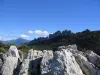
Sea of Rocks
7.9
18
Hike in Sauve
Easy
1:00, 2 km (change in altitude 0m)
Overlooking the medieval city of Sauve, this rocky chaos presents a magical landscape where vegetation and rocks with astonishing shapes mingle. Follow the yellow markings. An educational and fun break to take during your journey with "Crunch…
Located
57 km
away of Saint-Gervais
Favourite
Itinerary
Source of the Boulon, Baude Rocks
5.6
9
Hike in Robion
Intermediate
3:00, 6 km (change in altitude 475m)
This walk across the rocky escarpments which provide a home for several birds of prey. It offers superb viewpoints over the Plain of the Comtat Venaissin, the Alpilles, and the Luberon Cliffs. This walk offers the chance to see the Boulon Cirque,…
Located
57 km
away of Saint-Gervais
Favourite
Itinerary
Robion - Maubec
5.0
3
Hike in Robion
Intermediate
3:00, 6 km (change in altitude 410m)
Walk allowing you to admire the view over the Alpilles, the Durance valley, Saint Jacques Hill; to the north, the Cévennes Mountains, the Dentelles de Montmirail, the Vaucluse Mountains, with Mont Ventoux as a backdrop; at the foot of the Luberon,…
Located
57 km
away of Saint-Gervais
Favourite
Itinerary
See more results
By continuing to browse our site, you are agreeing to the use of cookies to improve your experience and make targeted offers.
Find out more and make settings
Close
Your account
Continue with my email