Liven up your holidays!

Dentelles de Montmirail Massif

Hikes & walks in Gigondas

Dentelles de Montmirail Massif - Hikes & walks in Gigondas
7.7
63

Easy walk for all. You will find a typical Mediterranean plant life and protected plants and animals. Wear a good pair of walking shoes and carry water and a whistle (during the hunting season). Respect nature (remove your waste) and the silence. Do not build campfires and do not pick flowers or camp. It is strictly prohibited. Only follow the signposting mentioned in the description. Important: a prefectoral decree regulates access to the Vaucluse Mountains during the summer season. Ask for information before setting out, any person in a closed massif may be liable for a €750 fine and legal proceedings. Contact the Tourist Offices/Town Halls or Vaucluse Prefecture. Since 1 March 2012, a municipal decree has come into force concerning circulation and parking in the Dentelles de Montmirail massif in the municipality of Gigondas (article L2213-1 to L2213-6 General Code for Local Authorities) and the highway code article L411-1. Parking of all vehicles is strictly prohibited on both sides of the road on the D.F.C.I. track in the Dentelles de Montmirail Massif between the Cayron Pass (leading to the communal road No.18) and the hamlet of Montmirail (leading to the communal road No.12) via the Alsau Pass. Owing to the nature of this road (D.F.C.I. track) all motorised vehicle are also prohibited on the same portion. The indications above will be visible on the site thanks to the regulatory signs with the specific symbols and, if necessary, the appropriate security barriers..
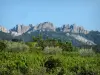
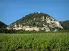
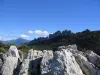
Description sheet

DepartmentVaucluse
Departure municipalityGigondas
Outing typeHike
DifficultyEasy
Duration2:00
Recommended periodfrom january to december
EnvironmentCountryside
Kilometres7 km
Altitude upon departure250m
Change in altitude200m

Access

Starting point: behind Gigondas Town Hall.

Itinerary

Start out from behind Gigondas Town Hall following the GRP trail (red and yellow marking) for less than a kilometre up a steep climb.

When you arrive at the crossroads, turn left towards "Dentelles de Montmirail" (blue signposting).

Climb to the viewpoint at the Midi Rock, where you will find an orientation table which offers a magnificent 360° view. This site has several picnic tables.

Take the CFCDI (very wide trail) along the bottom of the Dentelles Sarrasines, which are not signposted.

After 1½ km, you will arrive at a very large space, the Cayron Pass, also used as a car park (not recommended because not suitable for motorised vehicles).

Read the sign about the Dentelles de Montmirail formation on the way. It is very interesting, and, from there, admire the vertical ridges so characteristic of this massif.

Follow signs towards "Gigondas". After about a hundred metres, the road becomes a paved road.

You then have two choices, either to descend to Gigondas via the tarmac road (outside the hotel "les Florets") or follow the blue signposting along the path that descends on the left to the tarmac road below, and return to the village of Gigondas through the wood and pass the Tonin fountain (on the map indicated as"itinéraire bis"). Following the secondary route, you will arrive on the last section of the GRP walk (red/yellow marking) and arrive at the entrance to the village.

Visit ideas nearby

By continuing to browse our site, you are agreeing to the use of cookies to improve your experience and make targeted offers.
Find out more and make settings
Your account