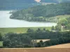


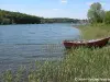
From the Tourist Office, cross the rue Diderot before turning right and down the Rue du Grand Cloître (located just before the statue Diderot). Once under the Henri IV door, go down the Côte des Trois-Rois. At the intersection with the D283, continue straight to the canal. There take the canal towpath on the left, in the direction of Rolampont. At the lock of Rolampont, exit the towpath on the left and enter the village by the street des Voies Dessous. After crossing the D1 taking a left, follow on the right the D254 towards Faverolles. After a few meters turn left at the junction with the D155 towards Faverolles. At the intersection with the D256 take this road on the right to join Faverolles. Then cross the village following the signs to the site of the Mausoleum (you will find on your left the archaeological museum that can be visited). After visiting the site in the forest, turn around to find the village and turn right on the D256 towards Marac. Then turn left onto the D143 in the same direction. Partially cross Marac by the D102 before turning right onto the D143 that will take you to Ormancey. Cross Ormancey and at the exit of the village follow the C5 which joins Mardor. Cross Mardor on the D255 before following the C2 towards Saint-Ciergues at the end of the village. In Saint-Ciergues, follow the D286 towards Perrancey which will take you through the dike and then along the lake. Then enter - Perrancey following the D135 on the left. Cross the village and follow the same road until Langres. At Langres, continue straight until the car wash station where you turn right to follow the greenway. At the crossroads, at the frog fountain, leave the greenway to climb the road that leads to the Blanchefontaine alley. At the top of the road take the path on the left, cross the bridge then Blanchefontaine to reach your destination. departure. All the tourist info on
Langres