Liven up your holidays!

Vaux-Rouillac

Tourism, holidays & weekends guide in the Charente

Vaux-Rouillac is a town in western Charente located 4 km south of Rouillac and 22 km west of Angouleme. It is located at the southern end of Canton Rouillac.

The village of Vaux is also 9 km northeast of Jarnac, 11 km northwest of Hiersac and 19 km east of Cognac.

Away from major roads, the town is bounded on the east by the D14 road to Rouillac Hiersac. The D736 Rouillac between Jarnac and passes northwest of the town. The village is served by the D66 and D119 which is the intersection.

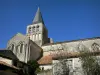
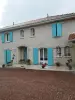
The village of Vaux-Rouillac, built on the sides and bottom of the hill leading to the source of Garland, alone includes most of the population.

The highest part of the town to the north, the view stretches far and discovers almost entirely Township Jarnac, which shares a border town of Vaux.

Outside the village, the town has only a few minor villages: King-of-Vaux, on top of a hill; At Peutier, south of the town, near the Garland; the Brandes, at the edge of the town of Echallat; At drooling, etc..

The municipality occupies a limestone plateau that descends gently to the south, and which belongs to Portlandian (Upper Jurassic). Some deposits of clay and gravel of the Tertiary exist locally in the north of the town (Little Bird Stained) and east (the Brandes).

The stony ground is suitable principally for growing vines.

The relief of the town is quite hilly, mainly north and east. Some valleys converge south of the town and the small valley of Garland, as the Valley of Nauton north, or Combe Lamie southeast.

The highlight of the town is at an altitude of 169 m, quite exceptional in this part of the department, located at the north end of town (old windmill). The lowest point is 58 m, located along the garland at the southern end. The village is about 100 m.

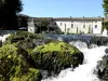
South of the town is watered by the Garland, small stream coming out of a rich source, but dry in summer on a part of its course, at the bottom of the valley which gave its name to the town, and which flows into the Charente between St. Simon and Bassac.

A bakery is the only trade in the common agricultural and wine which has a brewery and a tiler.

Geographical information

MunicipalityVaux-Rouillac
Postcode16170
Latitude45.7426600 (N 45° 44’ 34”)
Longitude-0.0913009 (W 0° 5’ 29”)
AltitudeFrom 58m to 169m
Surface area13.37 km²
Population301 inhabitants
Density22 inhabitants/km²
PrefectureAngoulême (27 km, 33 min)
Insee code16395
IntercommunalityCC du Rouillacais
DepartmentCharente
TerritoryCharentes
RegionNew-Aquitaine

Nearest cities & towns

Fleurac3 km (5 min)
Foussignac4.5 km (7 min)
Rouillac5 km (7 min)
Échallat5.4 km (9 min)
Mérignac5.7 km (9 min)
Sigogne6.8 km (9 min)
Mareuil7.7 km (12 min)
Courbillac8.8 km (15 min)
Triac-Lautrait9 km (15 min)
Saint-Cybardeaux9.1 km (13 min)
Douzat9.6 km (14 min)
Saint-Amant-de-Nouère10.1 km (17 min)
Bassac10.2 km (17 min)
Les Métairies10.4 km (12 min)

Things to see and do

You can still see the remains of an ancient house, the seat of a fee which, in the 14th century belonged to the family Geoffroy. In the first quarter of this century, Geoffrey, Lord of Vaux, married Isabella of Mosnac, widow of Jocelyn Mosnac, and became by this marriage, Lord of partially Mosnac. In the 16th century, the manor of Vaux was passed into the hands of the family de Montalembert, who kept it long enough. May 17, 1628, Jacques de Montalembert, Lord Vaux, appeared in the act by which the two brothers, Jacques and Guy de Montalembert, yielded to John Thomas, Esquire, the fief of Saint-Simon.

There is no monument or part classified on the town, the church dates from the late 19th century.

Environmental heritage of the valley with Garland is marked by springs and fountains.

Weather

Wednesday 15 may
Min. 11°C - Max. 15°C
Day
Night
Thursday 16 may
Min. 10°C - Max. 18°C
Day
Night
Friday 17 may
Min. 13°C - Max. 17°C
Day
Night

Visits, leisure and activities nearby

Leisure activities

Last nameActivity typeRateCity
Tour and tasting at the Domaine Montansier
Local flavoursFreeGraves-Saint-Amant (11 km)
Treetop rope course and giant ziplines
Sports sensations10 € to 20 € Saint-Bris-des-Bois (29 km)
Face de Tract Escape Game
Entertainment52 € to 84 € La Rochefoucauld-en-Angoumois (37 km)
Le Ferron animal park
Nature and the great outdoors5 € to 8 € Condéon (39 km)

Outings

Last nameOuting typeDifficultyDurationDeparture municipality
Botanical trail
HikeEasy1:00Mons (15.8 km)
Trotte-Renard Mill
Village visitEasy1:30Bunzac (35 km)
River side & nature side
HikeEasy1:05Saintes (42 km)
Saintes - Saintonge, the Gallo-Roman heritage
HikeEasy4:05Saintes (43 km)
Loop of Vendoire
HikeEasy2:30Vendoire (48 km)

Restaurants

Bed & breakfasts

Vacation rentals

Campsites

Hotels

Your holidays
A hotel
A vacation rental
A bed & breakfast
A campsite
A leisure activity
A restaurant
A rental car
A plane ticket
By continuing to browse our site, you are agreeing to the use of cookies to improve your experience and make targeted offers.
Find out more and make settings
Your account