Liven up your holidays!

Saint-Étienne-de-Tinée

Tourism, holidays & weekends guide in the Alpes-Maritimes

Saint-Étienne-de-Tinée - Tourism, holidays & weekends guide in the Alpes-Maritimes
7.6
9

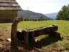
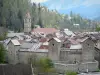
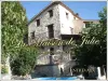
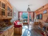
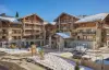
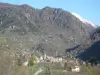
The village is located Saint-Étienne-de-Tinée 1140 m above sea level, just 90 km from Nice and 7 km from the resort of Auron. With approximately 1350 inhabitants, capital of canton has preserved authenticity, charm and architecture unique to specific villages in the valley.

Probably inhabited since prehistoric times, Insula Daeliae named by the Romans, then Santi Stephani Tinaesis by early Christians, Saint-Étienne de-Tinée had a very long history. It belongs to the Savoy before annexation to France in 1860. Life was so harsh. We lived then folded on itself, because of the very difficult routes with the neighboring valleys and coastline. From 1900, the widening of roads and the advent of the automobile enabled the city to grow, but a disastrous fire destroyed the 1929. Half the town was destroyed and its revival due Saint-Étienne-de-Tinée not only launched a subscription to all municipalities of France and the dynamism of its mayor Rovery Maurice, who was behind the resort of Auron.

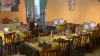
The villagers kept carefully and perpetuate new generations with the secret of many local recipes. A mixture of original and delicious mountain specialties with influences of Provencal cuisine, such as: gnocchi, ravioli, green pasta with wild spinach, polenta black, nettle soup, fried squash blossoms, coffee barley ... without forgetting the many handicrafts made by true alchemists of taste that make us discover new flavors through: jams, honeys "nature" or flavored gingerbread, but the cheese ...

Geographical information

MunicipalitySaint-Étienne-de-Tinée
Postcode06660
Tourism labels
Latitude44.2555539 (N 44° 15’ 20”)
Longitude6.9254410 (E 6° 55’ 32”)
AltitudeFrom 949m to 3027m
Surface area173.81 km²
Population1566 inhabitants
Density9 inhabitants/km²
PrefectureNice (89 km, 1:30)
Insee code06120
IntercommunalityME Métropole Nice Côte d'Azur
DepartmentAlpes-Maritimes
TerritoriesAlps, French Riviera
RegionProvence-Alps-French Riviera

Nearest cities & towns

Auron7.5 km (12 min)
Saint-Dalmas-le-Selvage7.6 km (14 min)
Isola15.3 km (18 min)
Saint-Sauveur-sur-Tinée29 km (31 min)
Roure38 km (46 min)
Roubion40 km (47 min)
Rimplas42 km (53 min)
Uvernet-Fours44 km (1:31)
Barcelonnette48 km (1:37)
Faucon-de-Barcelonnette51 km (1:40)
Beuil52 km (1:05)
Le Sauze53 km (1:42)
Pierlas54 km (1:11)
Enchastrayes54 km (1:44)
Jausiers57 km (1:45)

Things to see and do

Italian style and mountain architecture "French" coexist without spoiling all to the delight of visitors. Lovers trompe-l'oeil will be delighted.

The interpretive trail around the village and the river "Tinée" you will discover all aspects of village life altitude.

Saint-Étienne-de-Tinée has 17 churches, including five magnificent churches and chapels from the 13th to the 17th century, decorated with remarkable frescoes classified. Many sundials. Several museums are reviving the long history of the valley and the legacy of our ancestors traditions museum, dairy, school and mill.

Finally, the télépulsé Pinatelle you will in a few cables, direct access to the ski resort of Auron and enjoy a panoramic view over the village and the valley. Hamlets character is also the goal of various walks or visits: Roya Douans, Rougelle The La Blache, The Cialancier, Le Pré du Loup Vens.

Places of interest

Information points
Leisure centres
Monuments
Natural sites

Events and festivities

Frequently monthly market on Friday morning.

The last Sunday in June: Feast of Transhumance.

At the end of July: Pilgrimage to Our Lady of the Most High.

At the beginning of August: Feast of Saint-Étienne-de-Tinée.

Photos

Summer view of Saint-Étienne-de-Tinée
See photo
Landscape winter Saint-Étienne-de-Tinée
See photo
Sitemap water Saint-Étienne-de-Tinée
See photo
Steeple village Saint-Étienne-de-Tinée
See photo
Village Saint-Étienne-de-Tinée - Tinée Valley
See photo

Weather

Sunday 1 september
Min. 11°C - Max. 20°C
Day
Night
Monday 2 september
Min. 10°C - Max. 20°C
Day
Night
Tuesday 3 september
Min. 10°C - Max. 19°C
Day
Night

Visits, leisure and activities nearby

The Col de la Bonnette - 2802 m altitude: the highest road in Europe, linking Nice to Briançon. At the top of Bonnette, the views are spectacular, the view of the northern Alps and Mount Viso in Italy is beautiful ... your binoculars!

The Mercantour National Park: the Common Saint-Étienne-de-Tinée lies at the edge of the Mercantour National Park, it is the starting point of many hiking trails inside the park as Vens Lake, Lake of Rabuons, Mount Ténibre ...

Leisure activities

Last nameActivity typeRateCity
Equestrian activity in the Ubaye Valley
Sports sensations65 € Jausiers (23 km)
Mountain survival course in the Ubaye valley
Nature and the great outdoors170 € Jausiers (24 km)
Snowshoeing in the Ubaye valley
Nature and the great outdoors250 € Jausiers (24 km)
Trekking under the stars in the Mercantour National Park
Nature and the great outdoors30 € Allos (24 km)
Mercantour wildlife hike from Allos
Sports sensations30 € Allos (24 km)

Outings

Last nameOuting typeDifficultyDurationDeparture municipality
Lakes Vens
HikeIntermediate6:30Saint-Étienne-de-Tinée
Rabuons Lake
Village visitAthletic7:00Saint-Étienne-de-Tinée
Tour of the lakes
HikeIntermediate3:30Entraunes (14.3 km)
Plateau of St. Barnaby
HikeEasy1:00Saint-Martin-d'Entraunes (18.2 km)
Black Wood Tour
HikeIntermediate3:00Valdeblore (30 km)

Restaurants

Bed & breakfasts

Vacation rentals

Campsites

Hotels

Your holidays
A hotel
A vacation rental
A bed & breakfast
A campsite
A leisure activity
A restaurant
A rental car
A plane ticket
By continuing to browse our site, you are agreeing to the use of cookies to improve your experience and make targeted offers.
Find out more and make settings
Your account