To see the triptychs (fifteenth century) restored the church.
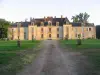
Remains of an ancient castle (walls, towers, ditches).
| Municipality | Ternant |
|---|---|
| Postcode | 58250 |
| Latitude | 46.7508780 (N 46° 45’ 3”) |
| Longitude | 3.8377920 (E 3° 50’ 16”) |
| Altitude | From 231m to 415m |
| Surface area | 19.38 km² |
| Population | 183 inhabitants |
| Density | 9 inhabitants/km² |
| Prefecture | Nevers (67 km, 1:15) |
| Insee code | 58289 |
| Intercommunality | CC Bazois Loire Morvan |
| Department | Nièvre |
| Territories | Burgundy, Nivernais |
| Region | Burgundy-Franche-Comté |
| Saint-Seine | 3.9 km (7 min) |
|---|---|
| Savigny-Poil-Fol | 5.5 km (9 min) |
| La Nocle-Maulaix | 5.6 km (7 min) |
| Tazilly | 7.2 km (10 min) |
| Cressy-sur-Somme | 8.4 km (15 min) |
| Lanty | 9.7 km (14 min) |
| Rémilly | 10 km (16 min) |
| Fléty | 10.4 km (15 min) |
| Maltat | 10.7 km (16 min) |
| Avrée | 12.4 km (19 min) |
| Grury | 12.9 km (22 min) |
| Luzy | 13.8 km (18 min) |
| Marly-sous-Issy | 15.7 km (19 min) |
| Fours | 15.8 km (19 min) |
To see the triptychs (fifteenth century) restored the church.
Remains of an ancient castle (walls, towers, ditches).
| Last name | Outing type | Difficulty | Duration | Departure municipality |
|---|---|---|---|---|
 | Hike | Intermediate | 3:30 | Thil-sur-Arroux (20 km) |
 | Hike | Easy | 2:00 | Thil-sur-Arroux (20 km) |
 | Hike | Athletic | 5:00 | Charbonnat (22 km) |
 | Hike | Intermediate | 3:00 | La Boulaye (22 km) |
 | Hike | Intermediate | 3:00 | Saint-Didier-sur-Arroux (23 km) |