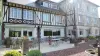
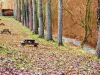
A nursing home became an orphanage in 1871, is now home "Marcel Callo," which was the first establishment of co-education in France.

Favourite
A nursing home became an orphanage in 1871, is now home "Marcel Callo," which was the first establishment of co-education in France.
| Municipality | Cempuis |
|---|---|
| Postcode | 60210 |
| Latitude | 49.6580430 (N 49° 39’ 29”) |
| Longitude | 1.9872420 (E 1° 59’ 14”) |
| Altitude | From 137m to 198m |
| Surface area | 9.38 km² |
| Population | 514 inhabitants |
| Density | 54 inhabitants/km² |
| Prefecture | Beauvais (32 km, 37 min) |
| Insee code | 60136 |
| Intercommunality | CC de la Picardie Verte |
| Department | Oise |
| Territory | Picardy |
| Region | Hauts-de-France |
| Le Hamel | 1.6 km (4 min) |
|---|---|
| Sommereux | 2.5 km (6 min) |
| Grez | 2.8 km (6 min) |
| Laverrière | 4.7 km (11 min) |
| Grandvilliers | 4.9 km (8 min) |
| Halloy | 5.5 km (8 min) |
| Hétomesnil | 5.7 km (8 min) |
| Gaudechart | 5.8 km (11 min) |
| Dargies | 6.1 km (11 min) |
| Prévillers | 6.7 km (12 min) |
| Conteville | 6.7 km (10 min) |
| Sarnois | 7 km (11 min) |
| Briot | 7 km (11 min) |
| Thieuloy-Saint-Antoine | 7.1 km (11 min) |
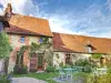
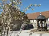
The chapel "Ecce Homo" date of 1728 and was renovated in 1986.
| Last name | Outing type | Difficulty | Duration | Departure municipality |
|---|---|---|---|---|
 | Hike | Easy | 3:00 | Courcelles-sous-Moyencourt (17.7 km) |
| Hike | Intermediate | 4:00 | Courcelles-sous-Moyencourt (17.7 km) |
 | Hike | Easy | 2:00 | Paillart (26 km) |
 | Hike | Easy | 50 min | Gournay-en-Bray (27 km) |
 | Village visit | Easy | 2:00 | Saint-Maulvis (30 km) |