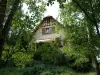
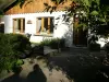
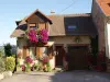
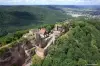
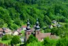
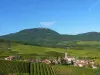
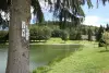
Village street a little more than 1500 inhabitants, Abreschviller follows the course of the upper valley of the Sarre Rouge for nearly 6 km, the last step before Donon summit of the Vosges sandstone.


Favourite


Village street a little more than 1500 inhabitants, Abreschviller follows the course of the upper valley of the Sarre Rouge for nearly 6 km, the last step before Donon summit of the Vosges sandstone.
| Municipality | Abreschviller |
|---|---|
| Postcode | 57560 |
| Tourism labels |  ") |
| Latitude | 48.6370280 (N 48° 38’ 13”) |
| Longitude | 7.0959040 (E 7° 5’ 45”) |
| Altitude | From 273m to 968m |
| Surface area | 41.29 km² |
| Population | 1437 inhabitants |
| Density | 34 inhabitants/km² |
| Prefecture | Metz (139 km, 1:29) |
| Insee code | 57003 |
| Intercommunality | CC Sarrebourg Moselle Sud |
| Department | Moselle |
| Territory | Lorraine |
| Region | Great East |
| Voyer | 2.9 km (5 min) |
|---|---|
| Vasperviller | 3.9 km (6 min) |
| Métairies-Saint-Quirin | 4.6 km (7 min) |
| Hartzviller | 6 km (9 min) |
| Saint-Quirin | 6.6 km (9 min) |
| Nitting | 7.2 km (7 min) |
| Walscheid | 7.4 km (10 min) |
| Hermelange | 8.7 km (10 min) |
| Troisfontaines | 8.9 km (14 min) |
| Laneuveville-lès-Lorquin | 9.1 km (12 min) |
| Lorquin | 9.5 km (10 min) |
| Hesse | 10.9 km (13 min) |
| Niderhoff | 10.9 km (13 min) |
| Lafrimbolle | 12.4 km (17 min) |
| Fraquelfing | 12.6 km (14 min) |
| Information points | |
|---|---|
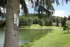
| Natural sites |


| Last name | Activity type | Rate | City |
|---|---|---|---|
 | Arts and Crafts | Free | Ranrupt (31 km) |
 | Entertainment | 24 € | Strasbourg (49 km) |
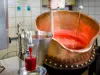
 | Local flavours | Free | Rodern (50 km) |
| Last name | Outing type | Difficulty | Duration | Departure municipality |
|---|---|---|---|---|
 | Hike | Intermediate | 5:25 | Saint-Quirin (3.7 km) |
 | Hike | Intermediate | 4:05 | Walscheid (4.5 km) |
 | Hike | Intermediate | 3:35 | Walscheid (4.5 km) |
 | Hike | Easy | 3:55 | Walscheid (4.5 km) |
 | Hike | Easy | 1:30 | Walscheid (4.5 km) |