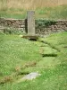
Shaded forest trail following the Bouzey supply canal and part of the old railway line which served the fortified outskirts of Épinal.
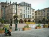
Épinal


Shaded forest trail following the Bouzey supply canal and part of the old railway line which served the fortified outskirts of Épinal.

| Department | Vosges |
|---|---|
| Departure municipality | Épinal |
| Outing type | Hike |
| Difficulty | Easy |
| Duration | 3:00 |
| Recommended period | from april to october |
| Environment | Countryside |
| Kilometres | 11 km |
| Change in altitude | 150m |
From the station, take the D51 towards Chantraine. After passing under the railway, you arrive at a traffic light. Follow Chantraine left. The climb takes you to a European crossroads. Turn left towards Renauvoid - Bains-les-Bains. You climb a little over 1.5 km, then slightly down about 400 m. At the foot of the descent turn right a paved road called Past Communale that goes to the forest. You leave your car there because you got to the starting point of the circuit.
GPS Coordinates: Latitude: 48.159989, Longitude: 6.427302
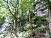
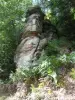
Facing the forest, turn left and follow the Marulaz forest road for 150 m, then turn right on to the path signposted with a red dot that descends towards Notre-Dame des 3 vallées (1). Follow the Bouzey Lake supply canal to Chemin d'Olima, which you will cross to climb up the path opposite that leads above the Olima Rocks (2).
You will arrive on a path which is the old railway line which served the fortified outskirts of Épinal. Turn right and make your way to the first house. Just after the gate, climb up the path on the left to the fitness trail signposted with a blue cross. Turn left and follow the signposting to the tarmac road.
Turn left on to this road and follow it for 150 m, then keep left on the signposted path (red dot). Pass next to Olima Farm (3) and leave it on your right and descend the stone path for 800 m. Following the signposting, turn right and cross a small wooden bridge over the stream and climb the steep path that leads you through Marquisat Forest.
Follow the signposting (red dot) to the edge of the forest where you will find a stone forest road near the hamlet of Basse Henri (4). Turn left on to this road, then 350 m further on, turn right. Climb up a path which arrives at the edge of the forest and which follows it to the houses. This path (1.6 km) takes you back to where you started.