


Favourite
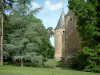
Ainay-le-Vieil Castle Park
| Municipality | Faverdines |
|---|---|
| Postcode | 18360 |
| Latitude | 46.6434820 (N 46° 38’ 37”) |
| Longitude | 2.4711910 (E 2° 28’ 16”) |
| Altitude | From 172m to 239m |
| Surface area | 18.51 km² |
| Population | 137 inhabitants |
| Density | 7 inhabitants/km² |
| Prefecture | Bourges (63 km, 52 min) |
| Insee code | 18093 |
| Intercommunality | CC Berry Grand Sud |
| Department | Cher |
| Territory | Berry |
| Region | Centre-Loire Valley |
| La Celette | 5.1 km (9 min) |
|---|---|
| Saulzais-le-Potier | 6.1 km (10 min) |
| Arcomps | 7.4 km (14 min) |
| Loye-sur-Arnon | 7.6 km (10 min) |
| La Groutte | 8.4 km (13 min) |
| Ainay-le-Vieil | 8.4 km (12 min) |
| Ardenais | 9.1 km (12 min) |
| Saint-Georges-de-Poisieux | 9.3 km (12 min) |
| Bouzais | 10.4 km (11 min) |
| Drevant | 10.7 km (16 min) |
| La Perche | 11.7 km (17 min) |
| Colombiers | 12.2 km (20 min) |
| Lételon | 13.1 km (18 min) |
| Orval | 13.2 km (15 min) |
| Last name | Activity type | Rate | City |
|---|---|---|---|
 | Culture and education | Free | Germigny-l'Exempt (44 km) |
 | Entertainment | 75 € to 120 € | Issoudun (50 km) |
| Last name | Outing type | Difficulty | Duration | Departure municipality |
|---|---|---|---|---|
 | Village visit | Easy | 1:00 | Hérisson (24 km) |
 | Hike | Easy | 3:00 | Moutier-Malcard (49 km) |
 | Hike | Easy | 2:00 | Chambon-sur-Voueize (51 km) |
 | Car itinerary | Easy | 1:35 | Évaux-les-Bains (52 km) |
 | Hike | Intermediate | 2:20 | Évaux-les-Bains (52 km) |