Liven up your holidays!
Destination
State your preferences
Guide
Plan your stay
Your account
English
Français
Deutsch
Italiano
Español
Nederlands
Português
Русский
简体中文
日本語
0
0
0
Guingamp
Menu
Tourism
Gastronomy
Outings
Activities
Events
Restaurants
Hotels
Vacation rentals
Bed & breakfasts
Campsites
Holiday insurance
Rental car
Train tickets
Plane tickets
Transfers
Holiday insurance
Holiday insurance
French courses
Romantic weekend
Family weekend
Cheap weekend
Unusual weekend
Find my position
Confirm
Discover
Tourist sites
Gastronomy
Cities & towns
Tourism labels
Themed itineraries
Custom itineraries
Photos
Panoramas
Tourism quiz
Going out
Leisure activities
Outings
Events
Restaurants
Stay
Hotels
Bed & breakfasts
Vacation rentals
Campsites
Travel
Rental car
Train tickets
Plane tickets
Holiday insurance
Information sheets
French courses
Outings
Around Guingamp
Outings in Guingamp
Ideas for walks and hikes in Guingamp
Search
Cancel
34
outings found
Guingamp
Change
Adjust destination
Town centre of Guingamp
Locality - Former locality Plouagat (Châtelaudren-Plouagat)
Transport - Train station of Guingamp
Transport - Train station of Brélidy-Plouec (Plouëc-du-Trieux)
Transport - Train station of Chatelaudren-Plouagat (Châtelaudren-Plouagat)
Transport - Train station of Coat-Guégan (Pont-Melvez)
Transport - Train station of Gourlan (Grâces)
Transport - Train station of Moustéru (Gurunhuel)
Information point - Tourist Office of Guingamp
Information point - Visitor Information Centre of Bourbriac (Bourbriac)
Leisure centre - Leisure Park Armoripark (Bégard)
Leisure centre - Racecourse of Bel Orme (Saint-Agathon)
Monument - Abbey Sainte-Croix
Monument - Basilica Notre-Dame de Bon-Secours
Monument - Castle of the Salles
Monument - Fountain of La Plomée
Monument - Castle of the Restmeur (Pommerit-le-Vicomte)
Monument - Chapel Notre-Dame de Lorette (Pédernec)
Monument - Chapel Notre-Dame du Danouët (Bourbriac)
Monument - Chapel Saint-Hervé du Menez Bré (Pédernec)
Monument - Chapel Saint-Yves (Plésidy)
Monument - Chapel of the Paradis (Pommerit-le-Vicomte)
Monument - Church Notre-Dame (Gurunhuel)
Monument - Church Notre-Dame (Pommerit-le-Vicomte)
Monument - Church Saint-Briac (Bourbriac)
Monument - Church Saint-Gilles (Saint-Gilles-les-Bois)
Monument - Church Saint-Pierre (Pédernec)
Monument - Manor of Toul-an-Golet (Plésidy)
Performance hall - Stadium of the Roudourou
Performance hall - Stadium Yves-Jaguin (Pabu)
Sort by distance from starting point
Sort by difficulty
Sort by change in altitude
Sort by duration
Sort by length in kilometres
Filter results
Open map
Outing type
Hike
Cycling itinerary
Horse ride
Other means of transport
Distance from starting point
Less than 10 km
from 10 km to 30 km
More than 30 km
Difficulty
Easy
Intermediate
Athletic
Change in altitude
Less than 200 m
from 200 m to 500 m
from 500 m to 1000 m
More than 1000 m
Duration
Less than 2 h
from 2 h to 4 h
More than 4 h
Kilometres
Less than 5 km
from 5 km to 10 km
from 10 km to 20 km
More than 20 km
Filter results
Hide filters
Open map
Hide map
Outings in Guingamp
Outings around Guingamp
Shooting Range Circuit
7.8
5
Mountain bike itinerary in Plouisy
Easy
30 min, 6 km (change in altitude 0m)
Mountain biking circuit without any major difficulties, just a few bumps.
Located
4.5 km
away of Guingamp
Favourite
Itinerary
GR 34 - Customs Officers' Path
6.0
15
Hike in Plouha
Intermediate
2:30, 13 km (change in altitude 0m)
Customs Officers' Path - GR 34 towards Paimpol. Short or long circuit leading from Plouha to Paimpol, via the cliff route with breathtaking views over Bréhat Island as your goal. Steep path with narrow sections: average difficulty.
Located
21 km
away of Guingamp
Favourite
Itinerary
Routoirs and Mill Path Circuit
7.3
4
Hike in Plourivo
Intermediate
1:30, 2 km (change in altitude 0m)
Routoirs circuit along the Trieux from the Maison de l'Estuaire in Penhoat (municipality of Plourivo) to Coat Ermit where you will find yourself at the Castle of Roche-Jagu. Mill path along the Leff river from Pont du Houel in Plourivo to Lanleff…
Located
22 km
away of Guingamp
Favourite
Itinerary
8.8
3
Hike in Plouaret
Easy
1:25, 5 km (change in altitude 65m)
Located
25 km
away of Guingamp
Favourite
Itinerary
Beauport Circuit
6.2
9
Hike in Paimpol
Easy
2:00, 10 km (change in altitude 60m)
Easy walk, with landscapes alternating between the sea, woods, lakes, marshes and valley. Two remarkable sites: Beauport Abbey and Sainte-Barbe Chapel.
Located
25 km
away of Guingamp
Favourite
Itinerary
7.8
3
Hike in Loguivy-Plougras
Easy
20 min, 1 km (change in altitude 19m)
Located
26 km
away of Guingamp
Favourite
Itinerary
9.0
6
Hike in Loguivy-Plougras
Intermediate
2:35, 8 km (change in altitude 201m)
Located
26 km
away of Guingamp
Favourite
Itinerary
The Haut Blavet and Faoudel Gorges
6.5
10
Village visit in Saint-Nicolas-du-Pélem
Intermediate
7:00, 20 km (change in altitude 200m)
Valleys circuit (1 day, 20 kilometres) From Kergoubleau, make your way to the Blavet valley and climb up it to the Toul Goulic Block Field. Kerne Uhel Lake appears at Pen ar C'hoat. Here, it is possible to turn on to an additional loop around…
Located
27 km
away of Guingamp
Favourite
Itinerary
6.7
3
Hike in Plounérin
Easy
2:15, 8 km (change in altitude 99m)
Located
29 km
away of Guingamp
Favourite
Itinerary
7.3
3
Hike in Lanvellec
Easy
1:50, 6 km (change in altitude 127m)
Located
29 km
away of Guingamp
Favourite
Itinerary
8.7
4
Hike in Plougras
Easy
55 min, 3 km (change in altitude 42m)
Located
29 km
away of Guingamp
Favourite
Itinerary
Locarn Moors and Corong Gorges
7.3
23
Hike in Locarn
Easy
1:00, 4 km (change in altitude 0m)
Discover the Locarn Moors, listed NATURA 2000 sites. Superb viewpoint from the ridge path. The Corong Gorges and the famous peat bogs are very easy to access.
Located
34 km
away of Guingamp
Favourite
Itinerary
8.8
2
Hike in Bolazec
Intermediate
3:05, 10 km (change in altitude 225m)
Located
35 km
away of Guingamp
Favourite
Itinerary
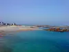
Ploumanac'h Natural Site
9.0
49
Hike in Perros-Guirec
Easy
3:00, 9 km (change in altitude 0m)
Set out to visit the Ploumanac'h Natural Site on the Pink Granite Coast.
Located
36 km
away of Guingamp
Favourite
Itinerary
House of the Bay at the forefront of Guettes
8.0
1
Hike in Hillion
Intermediate
1:30, 3 km (change in altitude 20m)
House of the Bay at the forefront of Guettes: rugged trail with some steep paths.
Located
36 km
away of Guingamp
Favourite
Itinerary
Panoramas of Hillion
8.5
2
Hike in Hillion
Athletic
5:10, 18 km (change in altitude 550m)
Panoramas of Hillion the ride to discover the beautiful scenery of Hillion in one ride.
Located
36 km
away of Guingamp
Favourite
Itinerary
Pissoison of the House of the Bay
8.5
2
Hike in Hillion
Intermediate
1:00, 2 km (change in altitude 20m)
Walk on the coast, on a rugged trail with some steep paths.
Located
36 km
away of Guingamp
Favourite
Itinerary
From Bon Abri to the Rolland Bridge
9.0
2
Hike in Hillion
Easy
2:30, 5 km (change in altitude 50m)
The Bon Abri dune massif contains a wide range of ecologically diverse habitats. The trail goes behind the dunes in order to prevent them from being trampled. From this trail, you can see the ponds, which can be home to up to seven amphibian…
Located
36 km
away of Guingamp
Favourite
Itinerary
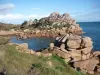
Traouïéro Valley
9.2
47
Hike in Trégastel
Intermediate
2:30, 8 km (change in altitude 5m)
A walk through the countryside from the town of Trégastel to the Grand Traouïéro valley with its stream, boundary with the town of Perros-Guirec. Visit the forests of this deep valley with its blockfield near the Pink Granite Coast.
Located
39 km
away of Guingamp
Favourite
Itinerary
8.0
7
Hike in Trégastel
Intermediate
3:05, 12 km (change in altitude 22m)
Located
40 km
away of Guingamp
Favourite
Itinerary
Circuit of the Old Station
8.0
1
Hike in Scrignac
Easy
4:30, 12 km (change in altitude 272m)
Beautiful hike in the countryside, quite difficult, which takes part of the GR 380. On your way, you will also pass on the old railway line which has become the Voie Verte n° 7 which is a portion of the Vélodyssée.
Located
42 km
away of Guingamp
Favourite
Itinerary
Seaside walk
4.9
10
Hike in Lamballe-Armor
Intermediate
3:00, 10 km (change in altitude 0m)
Between the countryside and the coast... The seaside between Jospinet and Dahouët offers a remarkable geological diversity, with rocky cliffs, a loess sea cliff, suspended valleys, as well as many botanical treasures as a result of how plants…
Located
42 km
away of Guingamp
Favourite
Itinerary
Mountain biking circuit
6.5
4
Cycling itinerary in Lamballe-Armor
Easy
2:00, 20 km (change in altitude 0m)
This circuit, which alternates between tarmac roads with a small amount of traffic and farm roads, is suitable for walking and for a family bicycle outing. It is a route which invites you to visit the countryside and discover the commune's heritage.…
Located
42 km
away of Guingamp
Favourite
Itinerary
9.2
3
Hike in Berrien
Intermediate
3:20, 11 km (change in altitude 218m)
Located
48 km
away of Guingamp
Favourite
Itinerary
8.9
2
Hike in Langoëlan
Intermediate
3:55, 12 km (change in altitude 352m)
Located
48 km
away of Guingamp
Favourite
Itinerary
See more results
By continuing to browse our site, you are agreeing to the use of cookies to improve your experience and make targeted offers.
Find out more and make settings
Close
Your account
Continue with my email