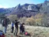
May 8: Hiking.


Favourite
| Municipality | Prondines |
|---|---|
| Postcode | 63470 |
| Latitude | 45.7608570 (N 45° 45’ 39”) |
| Longitude | 2.6764190 (E 2° 40’ 35”) |
| Altitude | From 757m to 1012m |
| Surface area | 30.91 km² |
| Population | 272 inhabitants |
| Density | 8 inhabitants/km² |
| Prefecture | Clermont-Ferrand (42 km, 48 min) |
| Insee code | 63289 |
| Intercommunality | CC Chavanon Combrailles et Volcans |
| Department | Puy-de-Dôme |
| Territories | Auvergne, Massif Central |
| Region | Auvergne-Rhône-Alps |
| Tortebesse | 4.8 km (12 min) |
|---|---|
| Sauvagnat | 5.3 km (8 min) |
| Cisternes-la-Forêt | 6.2 km (9 min) |
| Gelles | 8.1 km (10 min) |
| Briffons | 8.8 km (16 min) |
| Puy-Saint-Gulmier | 9.4 km (15 min) |
| Herment | 10 km (13 min) |
| Saint-Hilaire-les-Monges | 11.4 km (16 min) |
| Saint-Germain-près-Herment | 13.4 km (20 min) |
| Verneugheol | 13.5 km (17 min) |
| Combrailles | 13.6 km (18 min) |
| Lastic | 13.8 km (20 min) |
| Heume-l'Église | 14.4 km (18 min) |
| Saint-Sulpice | 16.6 km (27 min) |
May 8: Hiking.

Roche bobble to Gelles.
Cascade near Gelles.
| Last name | Activity type | Rate | City |
|---|---|---|---|
 | Nature and the great outdoors | 7 € | Chapdes-Beaufort (21 km) |
 | Nature and the great outdoors | 140 € to 240 € | Volvic (30 km) |
 | Sports sensations | 20 € | Lanobre (38 km) |
| Last name | Outing type | Difficulty | Duration | Departure municipality |
|---|---|---|---|---|
 | Cycling itinerary | Intermediate | 4:35 | Miremont (15.7 km) |
 | Cycling itinerary | Intermediate | 20 min | Murat-le-Quaire (18.6 km) |
 | Hike | Intermediate | 1:05 | Aydat (23 km) |
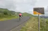 | Cycling itinerary | Athletic | 35 min | Mont-Dore (24 km) |
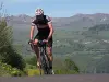 | Cycling itinerary | Intermediate | 40 min | Picherande (32 km) |