
Favourite
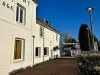
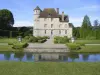
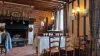
Vascoeuil Castle
| Municipality | Letteguives |
|---|---|
| Postcode | 27910 |
| Latitude | 49.4254130 (N 49° 25’ 31”) |
| Longitude | 1.3287300 (E 1° 19’ 43”) |
| Altitude | From 72m to 149m |
| Surface area | 4.10 km² |
| Population | 210 inhabitants |
| Density | 51 inhabitants/km² |
| Prefecture | Evreux (58 km, 1:06) |
| Insee code | 27366 |
| Intercommunality | CC Lyons Andelle |
| Department | Eure |
| Region | Normandy |
| Auzouville-sur-Ry | 2.7 km (8 min) |
|---|---|
| Fresne-le-Plan | 3.3 km (8 min) |
| Renneville | 4 km (9 min) |
| Perruel | 4.1 km (9 min) |
| Vascoeuil | 5.9 km (11 min) |
| Mesnil-Raoul | 6.3 km (10 min) |
| Perriers-sur-Andelle | 6.4 km (10 min) |
| Bourg-Beaudouin | 6.8 km (9 min) |
| Vandrimare | 7 km (14 min) |
| Martainville-Épreville | 7.4 km (12 min) |
| Ry | 7.8 km (15 min) |
| Montmain | 7.9 km (13 min) |
| Saint-Denis-le-Thiboult | 8.2 km (14 min) |
| Last name | Activity type | Rate | City |
|---|---|---|---|
 | Entertainment | 40 € | Sotteville-lès-Rouen (16.6 km) |
 | Nature and the great outdoors | 12 € to 16 € | Saint-Denis-sur-Scie (34 km) |
| Last name | Outing type | Difficulty | Duration | Departure municipality |
|---|---|---|---|---|
 | Hike | Intermediate | 1:40 | Auzouville-sur-Ry (2.3 km) |
 | Hike | Intermediate | 1:35 | Saint-Denis-le-Thiboult (4.5 km) |
 | Hike | Intermediate | 1:55 | Mesnil-Raoul (4.9 km) |
 | Hike | Intermediate | 2:15 | Ry (5.2 km) |
 | Hike | Intermediate | 1:40 | Bois-d'Ennebourg (5.3 km) |