
Favourite
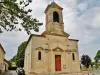
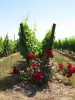
Saint-Pierre de Petit-Palais-et-Cornemps Church


| Municipality | Les Artigues-de-Lussac |
|---|---|
| Postcode | 33570 |
| Latitude | 44.9713290 (N 44° 58’ 17”) |
| Longitude | -0.1405700 (W 0° 8’ 26”) |
| Altitude | From 18m to 66m |
| Surface area | 10.16 km² |
| Population | 1133 inhabitants |
| Density | 111 inhabitants/km² |
| Prefecture | Bordeaux (47 km, 48 min) |
| Insee code | 33014 |
| Intercommunality | CC du Grand Saint-Émilionnais |
| Department | Gironde |
| Territory | Aquitaine |
| Region | New-Aquitaine |
| Lussac | 5.3 km (10 min) |
|---|---|
| Montagne | 6.5 km (10 min) |
| Saint-Denis-de-Pile | 6.5 km (9 min) |
| Petit-Palais-et-Cornemps | 7.3 km (12 min) |
| Néac | 7.6 km (10 min) |
| Abzac | 8.2 km (9 min) |
| Bonzac | 9.4 km (13 min) |
| Coutras | 9.6 km (14 min) |
| Lalande-de-Pomerol | 9.7 km (11 min) |
| Pomerol | 9.7 km (11 min) |
| Saint-Médard-de-Guizières | 10.5 km (12 min) |
| Savignac-de-l'Isle | 10.5 km (12 min) |
| Puisseguin | 11 km (17 min) |
| Saint-Sauveur-de-Puynormand | 11.2 km (20 min) |
| Monuments |
|---|
| Last name | Activity type | Rate | City |
|---|---|---|---|
 | Local flavours | Free | Saint-Médard-de-Guizières (7.9 km) |
 | Nature and the great outdoors | 35 € | Guîtres (8.7 km) |
 | Nature and the great outdoors | 15 € | Guîtres (8.7 km) |
 | Sports sensations | 12 € to 20 € | Pessac-sur-Dordogne (24 km) |
 | Nature and the great outdoors | 10 € to 60 € | Port-Sainte-Foy-et-Ponchapt (31 km) |
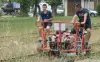
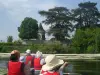
| Last name | Outing type | Difficulty | Duration | Departure municipality |
|---|---|---|---|---|
 | Hike | Easy | 1:00 | Sablons (7.1 km) |
 | All-terrain bike itinerary | Intermediate | 1:30 | Saint-Émilion (8.7 km) |
 | All-terrain bike itinerary | Easy | 45 min | Marcenais (18.2 km) |
 | Hike | Easy | 2:30 | Bossugan (21 km) |
 | Hike | Intermediate | 3:25 | Cubnezais (24 km) |