


Favourite
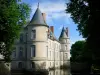
Haroué Castle
| Municipality | Gélaucourt |
|---|---|
| Postcode | 54115 |
| Tourism label | ") |
| Latitude | 48.4545800 (N 48° 27’ 16”) |
| Longitude | 5.9898910 (E 5° 59’ 24”) |
| Altitude | From 295m to 395m |
| Surface area | 2.26 km² |
| Population | 54 inhabitants |
| Density | 23 inhabitants/km² |
| Prefecture | Nancy (37 km, 39 min) |
| Insee code | 54218 |
| Intercommunality | CC du Pays de Colombey et du Sud Toulois |
| Department | Meurthe-et-Moselle |
| Territory | Lorraine |
| Region | Great East |
| Battigny | 2.1 km (4 min) |
|---|---|
| Laloeuf | 2.2 km (5 min) |
| Favières | 3.5 km (8 min) |
| Vandeléville | 5.1 km (8 min) |
| Thorey-Lyautey | 5.3 km (9 min) |
| Ognéville | 6.1 km (7 min) |
| Vitrey | 6.3 km (10 min) |
| Saulxerotte | 6.4 km (11 min) |
| Étreval | 6.7 km (12 min) |
| Dommarie-Eulmont | 6.7 km (10 min) |
| Goviller | 7.1 km (13 min) |
| Fécocourt | 8.4 km (12 min) |
| Vézelise | 8.6 km (10 min) |
| Hammeville | 8.9 km (14 min) |
| Chaouilley | 9.2 km (16 min) |
| Leisure centres |
|---|
| Last name | Activity type | Rate | City |
|---|---|---|---|
 | Local flavours | Free | Sorcy-Saint-Martin (39 km) |
| Last name | Outing type | Difficulty | Duration | Departure municipality |
|---|---|---|---|---|
 | Hike | Easy | 7:35 | Vaudémont (7.7 km) |
 | Hike | Intermediate | 3:20 | Maxey-sur-Meuse (22 km) |
 | Hike | Easy | 1:55 | Neufchâteau (24 km) |
 | Hike | Intermediate | 5:00 | Charmes (24 km) |
 | Hike | Easy | 1:30 | Vigneulles (28 km) |