


Favourite
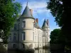
Haroué Castle
| Municipality | Goviller |
|---|---|
| Postcode | 54330 |
| Latitude | 48.4975350 (N 48° 29’ 51”) |
| Longitude | 6.0096610 (E 6° 0’ 35”) |
| Altitude | From 272m to 439m |
| Surface area | 12.12 km² |
| Population | 429 inhabitants |
| Density | 35 inhabitants/km² |
| Prefecture | Nancy (35 km, 36 min) |
| Insee code | 54235 |
| Intercommunality | CC du Pays du Saintois |
| Department | Meurthe-et-Moselle |
| Territory | Lorraine |
| Region | Great East |
| Dolcourt | 2.9 km (7 min) |
|---|---|
| Vitrey | 3.9 km (7 min) |
| Crépey | 4.7 km (4 min) |
| Selaincourt | 4.7 km (7 min) |
| Hammeville | 4.7 km (7 min) |
| Laloeuf | 5.1 km (8 min) |
| Vézelise | 6.2 km (7 min) |
| Gélaucourt | 7.1 km (13 min) |
| Parey-Saint-Césaire | 7.9 km (9 min) |
| Battigny | 8 km (12 min) |
| Germiny | 8.2 km (11 min) |
| Étreval | 8.2 km (16 min) |
| Thorey-Lyautey | 8.2 km (14 min) |
| Quevilloncourt | 8.6 km (11 min) |
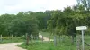
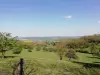
| Natural sites |
|---|
| Last name | Activity type | Rate | City |
|---|---|---|---|
 | Local flavours | Free | Sorcy-Saint-Martin (36 km) |
| Last name | Outing type | Difficulty | Duration | Departure municipality |
|---|---|---|---|---|
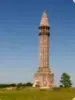 | Hike | Easy | 7:35 | Vaudémont (10.7 km) |
 | Hike | Intermediate | 3:20 | Maxey-sur-Meuse (24 km) |
 | Hike | Intermediate | 5:00 | Charmes (25 km) |
 | Hike | Easy | 1:30 | Vigneulles (25 km) |
 | Hike | Easy | 2:00 | Villey-Saint-Étienne (26 km) |