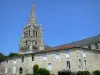
The common Fomperron retains some traces of the former Cistercian Abbey of Châtelliers.


Favourite
The common Fomperron retains some traces of the former Cistercian Abbey of Châtelliers.
| Municipality | Fomperron |
|---|---|
| Postcode | 79340 |
| Latitude | 46.4774030 (N 46° 28’ 39”) |
| Longitude | -0.1076250 (W 0° 6’ 27”) |
| Altitude | From 149m to 191m |
| Surface area | 17.40 km² |
| Population | 409 inhabitants |
| Density | 23 inhabitants/km² |
| Prefecture | Niort (46 km, 37 min) |
| Insee code | 79121 |
| Intercommunality | CC de Parthenay-Gâtine |
| Department | Deux-Sèvres |
| Territory | Poitou |
| Region | New-Aquitaine |
| Les Châteliers | 5 km (7 min) |
|---|---|
| Ménigoute | 5.4 km (7 min) |
| Saint-Germier | 8.7 km (12 min) |
| Exireuil | 8.9 km (14 min) |
| Nanteuil | 9.8 km (15 min) |
| Sanxay | 10 km (16 min) |
| Clavé | 10 km (14 min) |
| Vautebis | 10.4 km (12 min) |
| Les Forges | 11.2 km (17 min) |
| Pamproux | 11.3 km (12 min) |
| Vausseroux | 11.7 km (13 min) |
| Soudan | 12.2 km (11 min) |
| Reffannes | 12.7 km (14 min) |
| Saint-Georges-de-Noisné | 13.5 km (19 min) |
Remnants of the former Cistercian Abbey of Châtelliers (private property not accessible to the public).
| Natural sites |
|---|
| Last name | Outing type | Difficulty | Duration | Departure municipality |
|---|---|---|---|---|
 | Hike | Intermediate | 3:45 | Saint-Michel-le-Cloucq (49 km) |
| Hike | Easy | 3:00 | Mouterre-Silly (57 km) |
 | Hike | Easy | 3:20 | Saint-Martin-l'Ars (58 km) |