The trail, marked Yellow, Yellow and Red on the common parts with the GR
Fontenay-le-Comte
The trail, marked Yellow, Yellow and Red on the common parts with the GR
| Department | Vendée |
|---|---|
| Departure municipality | Saint-Michel-le-Cloucq |
| Outing type | Hike |
| Difficulty | Intermediate |
| Duration | 3:45 |
| Recommended period | from march to october |
| Kilometres | 12 km |
| Altitude upon departure | 104m |
| Change in altitude | 100m |
The start of the hike is on the church square.
From the church square, borrowing streets, join the north end of the village. Go along the sports field to get into the woods and down to the Vendée.
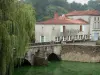
Once at the bottom, turn right and walk along the south end of the rocky promontory before crossing the bridge over the river.
Take the left path that climbs towards the village of Braud. Go around the quarry and back down to the D116.
Turn left to take about 300 meters on the left a grassy path then follows the creek downstream of CORNELIERE then the Vendée and then joined the Perrure bridge.
Cross the bridge and go up the D65 to the left for 300 meters. Take the forest road to the left towards the edge.
Turn right the first time then, at the cottage, a second time to take the road to the water tower.
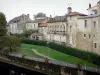
Walk along the D65 and then the car left the road, take the path that borders a pond. Then you arrive on the GR Country which opens to the corner of the castle grounds Mazeau, cross the D104 and down to the plains.
Turn left and follow the perimeter wall of the Château de Beaulieu. Continue to the village of Brelouze.
The trail reaches the D104 and joined the village Saint-Michel-le-Cloucq.