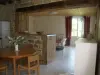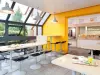
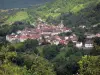


Favourite
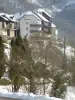
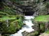
The source of the Loue river
| Municipality | Évillers |
|---|---|
| Postcode | 25520 |
| Latitude | 47.0008200 (N 47° 0’ 3”) |
| Longitude | 6.2261879 (E 6° 13’ 34”) |
| Altitude | From 690m to 933m |
| Surface area | 13.02 km² |
| Population | 396 inhabitants |
| Density | 30 inhabitants/km² |
| Prefecture | Besançon (53 km, 46 min) |
| Insee code | 25229 |
| Intercommunality | CC Altitude 800 |
| Department | Doubs |
| Territories | Franche-Comté, Jura mountains |
| Region | Burgundy-Franche-Comté |
| Septfontaines | 4.6 km (8 min) |
|---|---|
| Longeville | 5.6 km (9 min) |
| Ouhans | 6 km (9 min) |
| Renédale | 7 km (9 min) |
| Sombacour | 7.9 km (12 min) |
| Bians-les-Usiers | 8.9 km (12 min) |
| Amathay-Vésigneux | 9.3 km (13 min) |
| Goux-les-Usiers | 10.1 km (14 min) |
| Saint-Gorgon-Main | 10.4 km (14 min) |
| Châteauvieux-les-Fossés | 10.6 km (16 min) |
| Levier | 10.9 km (15 min) |
| Lods | 11.2 km (17 min) |
| Reugney | 11.7 km (16 min) |
| Aubonne | 12.3 km (15 min) |
| Last name | Activity type | Rate | City |
|---|---|---|---|
 | Entertainment | 84 € to 110 € | Besançon (30 km) |
 | Sports sensations | 50 € | Foncine-le-Bas (43 km) |
 | Sports sensations | 38 € | Chapelle-des-Bois (45 km) |
| Last name | Outing type | Difficulty | Duration | Departure municipality |
|---|---|---|---|---|
 | Hike | Easy | 1:05 | La Rivière-Drugeon (15.1 km) |
 | Hike | Intermediate | 35 min | Hauterive-la-Fresse (18.4 km) |
 | Hike | Easy | 3:00 | Arbois (36 km) |
 | Hike | Easy | 6:00 | Devecey (39 km) |
 | Hike | Easy | 1:45 | Poligny (44 km) |