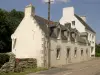
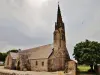
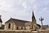
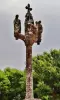
Visit the ruins of the chapel Languidou.


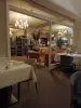
Favourite
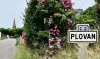


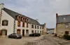
| Municipality | Plovan |
|---|---|
| Postcode | 29720 |
| Latitude | 47.9169530 (N 47° 55’ 1”) |
| Longitude | -4.3635490 (W 4° 21’ 49”) |
| Surface area | 15.75 km² |
| Population | 703 inhabitants |
| Density | 44 inhabitants/km² |
| Prefecture | Quimper (27 km, 35 min) |
| Insee code | 29214 |
| Intercommunality | CC du Haut Pays Bigouden |
| Department | Finistère |
| Region | Brittany |
| Tréogat | 3.9 km (6 min) |
|---|---|
| Pouldreuzic | 5 km (9 min) |
| Tréguennec | 5.8 km (12 min) |
| Plonéour-Lanvern | 7.5 km (11 min) |
| Peumerit | 8.7 km (14 min) |
| Landudec | 10.5 km (14 min) |
| Saint-Jean-Trolimon | 11.8 km (15 min) |
| Plozévet | 12 km (17 min) |
| Plogastel-Saint-Germain | 12.4 km (20 min) |
| Pont-l'Abbé | 14.1 km (19 min) |
| Guiler-sur-Goyen | 14.5 km (21 min) |
| Plomeur | 14.7 km (19 min) |
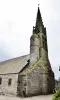
Visit the ruins of the chapel Languidou.
| Last name | Outing type | Difficulty | Duration | Departure municipality |
|---|---|---|---|---|
 | Hike | Intermediate | 3:40 | Saint-Jean-Trolimon (7.2 km) |
 | Hike | Intermediate | 3:35 | Gouézec (37 km) |
 | Hike | Intermediate | 1:30 | Gouézec (40 km) |
 | Hike | Intermediate | 3:35 | Gouézec (41 km) |
 | Hike | Intermediate | 4:20 | Roscanvel (46 km) |