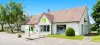
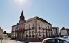
See the website of big gun.
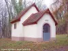
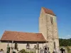
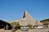
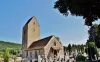
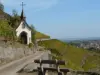
The chapel of Saint-Brice.
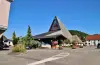
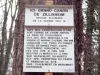
The Celtic camp.


| Municipality | Illfurth |
|---|---|
| Postcode | 68720 |
| Tourism label | ") |
| Latitude | 47.6720350 (N 47° 40’ 19”) |
| Longitude | 7.2648260 (E 7° 15’ 53”) |
| Altitude | From 255m to 391m |
| Surface area | 9.16 km² |
| Population | 2529 inhabitants |
| Density | 276 inhabitants/km² |
| Prefecture | Colmar (55 km, 43 min) |
| Insee code | 68152 |
| Intercommunality | CC Sundgau |
| Department | Haut-Rhin |
| Territory | Alsace |
| Region | Great East |
| Tagolsheim | 2.5 km (5 min) |
|---|---|
| Froeningen | 2.9 km (7 min) |
| Heidwiller | 3 km (5 min) |
| Walheim | 3.5 km (5 min) |
| Zillisheim | 3.9 km (6 min) |
| Luemschwiller | 4 km (8 min) |
| Hochstatt | 4.8 km (7 min) |
| Flaxlanden | 5.3 km (8 min) |
| Saint-Bernard | 5.6 km (8 min) |
| Spechbach | 5.8 km (9 min) |
| Wittersdorf | 7.1 km (9 min) |
| Aspach | 7.4 km (12 min) |
| Brunstatt-Didenheim | 7.6 km (10 min) |
| Eglingen | 8 km (11 min) |
| Altkirch | 8.2 km (14 min) |
See the website of big gun.
The chapel of Saint-Brice.
The Celtic camp.
| Last name | Activity type | Rate | City |
|---|---|---|---|
 | Culture and education | 11 € | Le Thillot (44 km) |
 | Culture and education | 6 € to 8 € | Labaroche (48 km) |
| Last name | Outing type | Difficulty | Duration | Departure municipality |
|---|---|---|---|---|
 | Hike | Intermediate | 1:00 | Burnhaupt-le-Haut (10.9 km) |
 | Hike | Intermediate | 1:05 | Thann (19.6 km) |
 | Village visit | Easy | 1:00 | Masevaux-Niederbruck (23 km) |
 | Hike | Intermediate | 3:00 | Masevaux-Niederbruck (23 km) |
 | Hike | Intermediate | 2:30 | Kirchberg (27 km) |