

Favourite
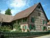
Sundgau


| Municipality | Wittersdorf |
|---|---|
| Postcode | 68130 |
| Tourism label | ") |
| Latitude | 47.6184210 (N 47° 37’ 6”) |
| Longitude | 7.2750560 (E 7° 16’ 30”) |
| Altitude | From 277m to 388m |
| Surface area | 4.76 km² |
| Population | 815 inhabitants |
| Density | 171 inhabitants/km² |
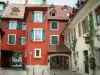
| Prefecture | Colmar (62 km, 52 min) |
| Insee code | 68377 |
| Intercommunality | CC Sundgau |
| Department | Haut-Rhin |
| Territory | Alsace |
| Region | Great East |
| Emlingen | 1.7 km (4 min) |
|---|---|
| Tagsdorf | 2.4 km (4 min) |
| Schwoben | 2.8 km (6 min) |
| Walheim | 3.6 km (6 min) |
| Heiwiller | 4.1 km (6 min) |
| Hausgauen | 4.1 km (6 min) |
| Altkirch | 4.6 km (8 min) |
| Hirsingue | 5.2 km (8 min) |
| Hundsbach | 5.5 km (8 min) |
| Tagolsheim | 5.6 km (9 min) |
| Aspach | 6 km (12 min) |
| Obermorschwiller | 6 km (16 min) |
| Wahlbach | 6.1 km (9 min) |
| Luemschwiller | 6.7 km (11 min) |
| Illfurth | 7.1 km (9 min) |
| Last name | Activity type | Rate | City |
|---|---|---|---|
 | Culture and education | 11 € | Le Thillot (48 km) |
| Last name | Outing type | Difficulty | Duration | Departure municipality |
|---|---|---|---|---|
 | Hike | Intermediate | 1:00 | Burnhaupt-le-Haut (15.6 km) |
 | Hike | Intermediate | 1:05 | Thann (25 km) |
 | Village visit | Easy | 1:00 | Masevaux-Niederbruck (27 km) |
 | Hike | Intermediate | 3:00 | Masevaux-Niederbruck (27 km) |
 | Hike | Intermediate | 2:30 | Kirchberg (31 km) |