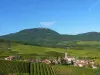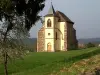


Small village perched from fifty inhabitants, characteristic of Piedmont Vosgien de Meurthe-et-Moselle, the first step of the Donon Massif dominating the Lorraine plateau, with a more forest tradition than peasant, Saint-Sauveur has a prestigious past that its current modesty Do not let guess. Its situation is remarkable, its relatively homogeneous habitat, and its isolation increases the charm. Its forest and mountainous territory extends far from the east, until the department of Bas-Rhin and limits the highlight of Meurthe-et-Moselle. It carries a lot of interesting tourist sites: the house of the Piedmont Forest Vosges and its refuge, the sawmill of Machete, and, for the small heritage, the chapel of your, the source of the vezouze, many remarkable rocks and its church., which leaves no one indifferent.
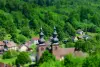
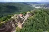
The abbey of Saint-Sauveur "in Vosges": the church that dominates the village in the middle of a meadow is the Gothic choir of the old abbey destroyed during the wars of religion and abandoned in 1569, ten years after its last restoration. A bell tower was applied against the choir without nave at the end of the 19th century. Important renovations were made in 1954 with the recovery of ogival berries until then and the restoration of original indoor purity. The establishment of the Benedictine Abbey of Good Moutier at Saint-Sauveur dates from 1010, after an original establishment in Val-et-Châtillon. Its foundation in the seventh century was contemporary with those of Senones, Menemoutier, Etival and Saint-Die, all of these first abbeys forming the "monastic cross of Lorraine" including Saint-Sauveur constitutes the head. After 1188, the canons of St. Augustine succeeded Benedictines. The abbey possessed immense forests to the Donon and had authority over many villages in the region, the Vallée de la Plaine, Blamontois, Badonvillois and the immediate sector. Without it seems to have never been very important by the number of monks, it became the necropolis of the greatest lords of the region, especially of Henry I of Blâmont, Sénéchal de Lorraine, great builder (Tour des Doupaés and Collegiate Saint Saint -Generalgers), cited in the tournament of Chavency (1285), and his wife Cunegonde de Linge. The lying of this illustrious couple, exposed to the Chapel of the Cordeliers in Nancy since 1854 after his discovery in the meadow of Saint-Sauveur, is the most beautiful of Lorraine. This is the search for the isolation that had pushed the monks to settle at Saint-Sauveur and it is the dangers of this isolation that forced them 560 years later to settle in Dovèvre, in a safer place.