Church of the Nativity of the Virgin (eleventh century): specificity, this church has no steeple.
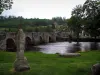
Viaduct (entirely in stone) of the existing line of railroad Guéret La Chatre.
| Municipality | Glénic |
|---|---|
| Postcode | 23380 |
| Latitude | 46.2235450 (N 46° 13’ 25”) |
| Longitude | 1.9225820 (E 1° 55’ 21”) |
| Altitude | From 293m to 521m |
| Surface area | 27.60 km² |
| Population | 698 inhabitants |
| Density | 25 inhabitants/km² |
| Prefecture | Guéret (8.2 km, 12 min) |
| Insee code | 23092 |
| Intercommunality | CA du Grand Guéret |
| Department | Creuse |
| Territories | Limousin, Massif Central |
| Region | New-Aquitaine |
| Saint-Fiel | 4.7 km (7 min) |
|---|---|
| Ajain | 7.1 km (12 min) |
| Jouillat | 7.2 km (9 min) |
| Guéret | 8 km (12 min) |
| Champsanglard | 9.1 km (12 min) |
| Roches | 11.1 km (14 min) |
| Saint-Sulpice-le-Guérétois | 12.4 km (16 min) |
| Pionnat | 12.4 km (22 min) |
| Ladapeyre | 12.6 km (19 min) |
| Sainte-Feyre | 12.6 km (17 min) |
| Anzême | 12.7 km (17 min) |
| Saint-Laurent | 12.8 km (17 min) |
| Bonnat | 14.2 km (17 min) |
| Châtelus-Malvaleix | 14.7 km (18 min) |
Church of the Nativity of the Virgin (eleventh century): specificity, this church has no steeple.
Viaduct (entirely in stone) of the existing line of railroad Guéret La Chatre.
The 1st Sunday of July: Day of the donkey (competition show marathon staging of the old life ...).
| Last name | Outing type | Difficulty | Duration | Departure municipality |
|---|---|---|---|---|
 | Car itinerary | Easy | 1:00 | Ahun (17.9 km) |
 | Hike | Easy | 3:00 | Moutier-Malcard (18.9 km) |
 | Village visit | Easy | 3:00 | Soubrebost (30 km) |
 | Hike | Easy | 1:30 | Bourganeuf (33 km) |
 | Car itinerary | Easy | 45 min | Saint-Sébastien (35 km) |