Liven up your holidays!

Auriac-du-Périgord

Tourism, holidays & weekends guide in the Dordogne

Auriac-du-Périgord - Tourism, holidays & weekends guide in the Dordogne
9.2
9

Formerly known Auriac-en-Perigord, then Auriac de Montignac, Auriac-du-Périgord should perhaps its name or some Aurius Aurelius who would install a "villa" Gallo-Roman.

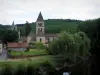
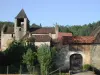
Between Thenon and Montignac, it nestles in the valley of Laurence whose average gradient of 1% allowed once the diet of many mills (15 mills were said count of 15 km). Its geographical location, north of the Black Perigord halfway between Perigueux and Brive, makes it a perfect place to stay, both quiet and near the most famous attractions: Lascaux, the Vezere Valley and Les Eyzies, Rouffignac, Hautefort and Sarlat.

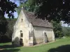
The town, itself, presents a valuable asset linked to its ancient history and particular. The Lordship of Auriac was created in 1487, following the sale by the lords of Albret (which will be home from King Henry IV of France) Rights and rents of land to the Cropte Antoinette wife of Pierre Arnal which the eldest son, François Arnal became lord of Faye and Auriac. This lordship is included in the county of Périgord while under the suzerainty of the house of Albret. Catholic in a Protestant environment, among the English French, Auriac cultivated its uniqueness as evidenced by numerous towers.

With over 200 "fires" and 1000 "souls" in Henry IV, despite episodes of plague and famine, Auriac remains under the Ancien Regime to count 256 "fires" and 1200 inhabitants in the Revolution. Auriac is essentially a common wine, the arrival of phylloxera in 1875 will cause an exodus of the population along the disappearance of the vineyard (1,088 inhabitants in 1881 to 805 h in 1891). After the first world war general phenomenon in France, the exodus will take even more intense. Population will decrease to 300 inhabitants in 1980. It rose to 430 people today.

Geographical information

MunicipalityAuriac-du-Périgord
Postcode24290
Latitude45.1071720 (N 45° 6’ 26”)
Longitude1.1350540 (E 1° 8’ 6”)
AltitudeFrom 93m to 293m
Surface area18.63 km²
Population411 inhabitants
Density22 inhabitants/km²
PrefecturePérigueux (56 km, 42 min)
Insee code24018
IntercommunalityCC Terrassonnais Haut Périgord Noir
DepartmentDordogne
TerritoriesAquitaine, Périgord
RegionNew-Aquitaine

Nearest cities & towns

La Bachellerie6.8 km (10 min)
Montignac-Lascaux7.2 km (9 min)
Thenon7.5 km (8 min)
Aubas7.9 km (10 min)
Bars9.9 km (18 min)
Azerat10.1 km (13 min)
Saint-Rabier10.8 km (15 min)
Les Farges11 km (14 min)
Peyrignac11.4 km (16 min)
Fanlac11.4 km (21 min)
Thonac12 km (15 min)
Ajat13.1 km (16 min)
Condat-sur-Vézère13.9 km (14 min)
Valojoulx14 km (19 min)

Things to see and do

Places of interest

Monuments

Events and festivities

Photos

The church of the 12th Century
See photo
The village in the countryside
See photo
Auriac, The Laurence River
See photo
The tower wall, typical of the Perigord
See photo
The laundry on the Laurence
See photo
La Chapelle Saint-Remy (Pilgrimage)
See photo

Weather

Friday 3 may
Min. 7°C - Max. 14°C
Day
Night
Saturday 4 may
Min. 9°C - Max. 14°C
Day
Night
Sunday 5 may
Min. 12°C - Max. 16°C
Day
Night

Visits, leisure and activities nearby

Leisure activities

Last nameActivity typeRateCity
Electric mountain bike hire
Sports sensations45 € Excideuil (26 km)
Hot air balloon flight over Périgord
Nature and the great outdoors130 € to 215 € Saint-Vincent-de-Cosse (30 km)
Comille Aventure treetop adventure park
Sports sensations20 € Cornille (31 km)
Canoe or kayak hire in the Dordogne
Sports sensations15 € to 25 € Carsac-Aillac (32 km)
Hermit’s Maze
Entertainment7 € to 9 € Domme (32 km)

Outings

Last nameOuting typeDifficultyDurationDeparture municipality
Boucle of Rouffignac
Mountain bike itineraryEasy1:00Rouffignac-Saint-Cernin-de-Reilhac (14 km)
Red sandstone
HikeEasy1:15Vars-sur-Roseix (25 km)
Saint-Michel d'Auberoche Chapel
HikeIntermediate4:00Antonne-et-Trigonant (27 km)
Historic walk in Lanmary Forest
HikeIntermediate5:00Antonne-et-Trigonant (27 km)
From Saint-Mesmin to the Savignac-Lédrier forges
HikeEasy4:00Saint-Mesmin (28 km)

Restaurants

Bed & breakfasts

Vacation rentals

Campsites

Hotels

Your holidays
A hotel
A vacation rental
A bed & breakfast
A campsite
A leisure activity
A restaurant
A rental car
A plane ticket
By continuing to browse our site, you are agreeing to the use of cookies to improve your experience and make targeted offers.
Find out more and make settings
Your account