


Favourite
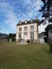
The Lucerne abbey
| Municipality | Saint-Sauveur-la-Pommeraye |
|---|---|
| Postcode | 50510 |
| Latitude | 48.8465680 (N 48° 50’ 48”) |
| Longitude | -1.4441270 (W 1° 26’ 39”) |
| Altitude | From 64m to 131m |
| Surface area | 5.27 km² |
| Population | 414 inhabitants |
| Density | 78 inhabitants/km² |
| Prefecture | Saint-Lô (64 km, 48 min) |
| Insee code | 50549 |
| Intercommunality | CC de Granville, Terre et Mer |
| Department | Manche |
| Region | Normandy |
| La Meurdraquière | 2.8 km (6 min) |
|---|---|
| Saint-Jean-des-Champs | 3.6 km (6 min) |
| Le Loreur | 4.3 km (5 min) |
| Folligny | 4.4 km (6 min) |
| Hocquigny | 5.8 km (8 min) |
| Équilly | 6 km (8 min) |
| Beauchamps | 7.6 km (10 min) |
| Ver | 8 km (14 min) |
| La Haye-Pesnel | 8.2 km (11 min) |
| Anctoville-sur-Boscq | 8.3 km (11 min) |
| Hudimesnil | 8.4 km (11 min) |
| Saint-Planchers | 8.5 km (12 min) |
| Cérences | 8.8 km (11 min) |
| Last name | Activity type | Rate | City |
|---|---|---|---|
 | Entertainment | Free | Champeaux (12.6 km) |
 | Sports sensations | 140 € | Le Val-Saint-Père (21 km) |
 | Arts and Crafts | Free | Dol-de-Bretagne (40 km) |
 | Sports sensations | 16 € to 24 € | Le Neufbourg (42 km) |
 | Entertainment | 29 € to 168 € | Saint-Malo (48 km) |
| Last name | Outing type | Difficulty | Duration | Departure municipality |
|---|---|---|---|---|
 | Hike | Intermediate | 3:30 | Le Mont-Saint-Michel (24 km) |
 | Hike | Easy | 3:15 | Reffuveille (28 km) |
 | Hike | Easy | 1:00 | Gouville-sur-Mer (31 km) |
 | Hike | Easy | 2:00 | Saint-Malo (48 km) |
 | Car itinerary | Easy | 7:00 | Carentan-les-Marais (53 km) |