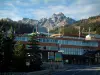
A route to discover the mountain level through forests and mountain pastures, with panoramas of the surrounding peaks.
Méribel


A route to discover the mountain level through forests and mountain pastures, with panoramas of the surrounding peaks.
| Department | Savoie |
|---|---|
| Departure municipality | La Léchère |
| Outing type | Hike |
| Difficulty | Easy |
| Duration | 4:00 |
| Recommended period | from june to october |
| Kilometres | 9 km |
| Altitude upon departure | 1250m |
| Change in altitude | 490m |
Departing from the spa resort of La Léchère, head towards Aigueblanche. At the first crow's foot intersection, turn right towards Doucy Station.
The start of the walk takes place in front of the Doucy Tourist Office.
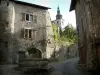
Start the route at the Doucy station and go down a small path, then an alpine path, towards the village of Doucy. Take a short passage on the road when crossing the village. This concludes by walking alongside the baroque Saint-André church, classified as a Historic Monument, whose developments on the Morel torrent at the beginning of the 20th century prevented it from falling several hundred meters below.
At the end of the alpine path, continue on a path which enters the Morel national forest a little before arriving near the torrent which flows in the center of the valley at the foot of impressive cliffs. Then cross the watercourse, the low point of the route, and begin the climb along it until arriving at the recently renovated Vieux Moulin.
At this level, recross the watercourse using a bridge and take an agricultural path which leads to the exit of the forest.
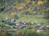
Cross Villaret, another typical village in the valley, via a new small passage on the road before joining a wide path through the sloping meadows. Stay on this path until arriving at Doucy station.