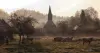
Liven up your holidays!
Destination
State your preferences
Guide
Plan your stay
Your account
English
Français
Deutsch
Italiano
Español
Nederlands
Português
Русский
简体中文
日本語
0
0
0
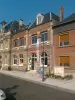
Cernay
Menu
Tourism
Gastronomy
Outings
Activities
Events
Restaurants
Hotels
Vacation rentals
Bed & breakfasts
Campsites
Holiday insurance
Rental car
Train tickets
Plane tickets
Transfers
Holiday insurance
Holiday insurance
French courses
Romantic weekend
Family weekend
Cheap weekend
Unusual weekend
Find my position
Confirm
Discover
Tourist sites
Gastronomy
Cities & towns
Tourism labels
Themed itineraries
Custom itineraries
Photos
Panoramas
Tourism quiz
Going out
Leisure activities
Outings
Events
Restaurants
Stay
Hotels
Bed & breakfasts
Vacation rentals
Campsites
Travel
Rental car
Train tickets
Plane tickets
Holiday insurance
Information sheets
French courses
Outings
Around Cernay
Outings in Cernay
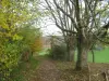
Ideas for walks and hikes in Cernay
Search
Cancel
21
outings found
Cernay
Change
Adjust destination
Town centre of Cernay
Locality - Former locality Auquainville (Livarot-Pays-d'Auge)
Locality - Former locality Bellou (Livarot-Pays-d'Auge)
Locality - Former locality Cerqueux (Livarot-Pays-d'Auge)
Locality - Former locality Cheffreville-Tonnencourt (Livarot-Pays-d'Auge)
Locality - Former locality Familly (Livarot-Pays-d'Auge)
Locality - Former locality Fervaques (Livarot-Pays-d'Auge)
Locality - Former locality Friardel (La Vespière-Friardel)
Locality - Former locality La Brévière (Val-de-Vie)
Locality - Former locality La Chapelle-Yvon (Valorbiquet)
Locality - Former locality La Croupte (Livarot-Pays-d'Auge)
Locality - Former locality La Vespière (La Vespière-Friardel)
Locality - Former locality Le Mesnil-Germain (Livarot-Pays-d'Auge)
Locality - Former locality Les Moutiers-Hubert (Livarot-Pays-d'Auge)
Locality - Former locality Livarot (Livarot-Pays-d'Auge)
Locality - Former locality Meulles (Livarot-Pays-d'Auge)
Locality - Former locality Notre-Dame-de-Courson (Livarot-Pays-d'Auge)
Locality - Former locality Préaux-Saint-Sébastien (Livarot-Pays-d'Auge)
Locality - Former locality Saint-Cyr-du-Ronceray (Valorbiquet)
Locality - Former locality Saint-Julien-de-Mailloc (Valorbiquet)
Locality - Former locality Saint-Ouen-le-Houx (Livarot-Pays-d'Auge)
Locality - Former locality Saint-Pierre-de-Mailloc (Valorbiquet)
Locality - Former locality Sainte-Foy-de-Montgommery (Val-de-Vie)
Locality - Former locality Sainte-Marguerite-des-Loges (Livarot-Pays-d'Auge)
Locality - Former locality Tordouet (Valorbiquet)
Information point - Tourist Office of Livarot (Livarot-Pays-d'Auge)
Information point - Tourist Office of Orbec (Orbec)
Leisure centre - Municipal Museum Le Vieux-Manoir (Orbec)
Leisure centre - Museum of Lisieux (Saint-Germain-de-Livet)
Monument - Castle of Saint-Germain-de-Livet (Saint-Germain-de-Livet)
Sort by distance from starting point
Sort by difficulty
Sort by change in altitude
Sort by duration
Sort by length in kilometres
Filter results
Open map
Outing type
Hike
Cycling itinerary
Horse ride
Other means of transport
Distance from starting point
Less than 10 km
from 10 km to 30 km
More than 30 km
Difficulty
Easy
Intermediate
Athletic
Change in altitude
Less than 200 m
from 200 m to 500 m
from 500 m to 1000 m
More than 1000 m
Duration
Less than 2 h
from 2 h to 4 h
More than 4 h
Kilometres
Less than 5 km
from 5 km to 10 km
from 10 km to 20 km
More than 20 km
Filter results
Hide filters
Open map
Hide map
Outings in Cernay
Outings around Cernay
Way of the Three Calvaries
5.8
6
Hike in Asnières
Easy
3:00, 9 km (change in altitude 100m)
Very nice walk of 9.5 km crossing village, wood, river, stud.
Located
19.7 km
away of Cernay
Favourite
Itinerary
Saint Helier Trail
8.0
1
Hike in Beuzeville
Easy
3:00, 12 km (change in altitude 186m)
Long country walk, old mills on the Morelle, view into the valley, river banks, chapel of the old castle of Neuilly (private), Saint Helier washhouse.
Located
36 km
away of Cernay
Favourite
Itinerary
Lavoir trail
6.3
3
Village visit in Beuzeville
Easy
1:00, 4 km (change in altitude 64m)
Forest path, large wash house and covered fountain of Saint Helier, passage through a typical courtyard and half-timbered houses. Yellow markings. In the village: Saint Hélier church from the 12th century with an exceptional set of 19 glass…
Located
36 km
away of Cernay
Favourite
Itinerary
Saracens Path
5.7
3
Hike in Condé-sur-Risle
Easy
3:00, 12 km (change in altitude 0m)
Follow the blue signs. To discover in the course of the walk: the Saracen fountain, the castle of the Thillaye, the landscapes of the valley of the Risle... map - leaflet available at the Tourist Office of Montfort-sur-Risle.
Located
39 km
away of Cernay
Favourite
Itinerary
Orchid trail
8.3
3
Hike in Boulleville
Easy
2:00, 8 km (change in altitude 114m)
Panoramas over the Val Durand, ford over the stream, springs and washhouse, many thatched cottages, landscapes alternating between the plain and the valley. Blue markings.
Located
39 km
away of Cernay
Favourite
Itinerary
Medieval legacy in the Val de Risle
4.5
2
Cycling itinerary in Montfort-sur-Risle
Easy
4:00, 12 km (change in altitude 1m)
The Montfort Tourist Information Point and the Montfort Culture and Heritage association invite you to discover the Medieval Heritage circuit in the Val de Risle. This circuit allows you to discover the history and architecture of the medieval…
Located
39 km
away of Cernay
Favourite
Itinerary
7.8
3
Hike in Pont-Audemer
Easy
35 min, 2 km (change in altitude 3m)
Located
40 km
away of Cernay
Favourite
Itinerary
Cliffs of Black Cows
6.4
7
Hike in Villers-sur-Mer
Easy
2:00, 7 km (change in altitude 0m)
Departure from the beach of Villers-sur-Mer towards the nautical center, only at low tide, you will go to the foot of the cliffs of the Black Vaches to admire the calm of this place, you will meet some people looking for fossils in the cliffs,…
Located
41 km
away of Cernay
Favourite
Itinerary
Vieux Pressoir path
7.0
3
Hike in Conteville
Easy
1:30, 5 km (change in altitude 128m)
Authentic long-grip press from the 17th century, forest and views over the estuary.
Located
43 km
away of Cernay
Favourite
Itinerary
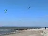
The beach, a fragile refuge
8.0
1
Hike in Cricqueboeuf
Athletic
4:30, 15 km (change in altitude 323m)
This circuit will take you to the heart of the Seine estuary, to discover the marine flora and fauna along the beach. You will then enter the heart of the Calvados countryside and discover magnificent viewpoints! Pay attention to the tide times!
Located
44 km
away of Cernay
Favourite
Itinerary
Hamlets trail
8.0
1
Hike in Conteville
Easy
3:00, 12 km (change in altitude 174m)
Marshes of the maritime Risle with very many tadpoles of willows, ash trees and poplars, edges of Risle, fountain of the Pré, paths in balcony with panoramas on the estuary, and the valley of Risle, authentic press. Blue markings.
Located
45 km
away of Cernay
Favourite
Itinerary
Stroll Impressionist
8.5
4
Village visit in Honfleur
Intermediate
2:00, 5 km (change in altitude 100m)
Bucolic walk in Honfleur and on the hills to the beach and the pier. Discover the most picturesque sites that have not escaped the Impressionists!
Located
45 km
away of Cernay
Favourite
Itinerary
Sails of Liberty Trail
7.5
2
Hike in Berville-sur-Mer
Easy
3:00, 12 km (change in altitude 130m)
Panoramas over the Seine estuary, Château de la Garenne, forest on the hill with a beautiful beech grove, church with marine votive offerings.
Located
46 km
away of Cernay
Favourite
Itinerary
Sea buckthorn trail
8.0
1
Hike in Berville-sur-Mer
Easy
3:00, 11 km (change in altitude 65m)
Panoramas over the Seine, mosaic of natural environments, preserved site. Walk on the alluvium of the Seine. Educational signs. Sensitive Natural Area of the Eure department. Yellow markings from point 4.
Located
46 km
away of Cernay
Favourite
Itinerary
Fl'Eure d'eau trail
8.0
1
Hike in Berville-sur-Mer
Easy
30 min, 2 km (change in altitude 62m)
Three quarters at the water's edge (the Seine, the Risle and the return canal), site of the mouth of the Risle flowing into the Seine, a former fishing port with its old boats on display. The course is decorated with educational panels and picnic…
Located
46 km
away of Cernay
Favourite
Itinerary
8.9
7
Cycling itinerary in La Bouille
Athletic
2:05, 36 km (change in altitude 137m)
Located
58 km
away of Cernay
Favourite
Itinerary
8.3
7
Hike in Sahurs
Athletic
3:45, 14 km (change in altitude 92m)
Located
58 km
away of Cernay
Favourite
Itinerary
8.0
2
Horse ride in Jumièges
Easy
2:05, 14 km (change in altitude 50m)
Located
58 km
away of Cernay
Favourite
Itinerary
9.0
4
Hike in Jumièges
Intermediate
2:55, 11 km (change in altitude 51m)
Located
58 km
away of Cernay
Favourite
Itinerary
8.2
4
Hike in Le Mesnil-sous-Jumièges
Intermediate
2:00, 7 km (change in altitude 75m)
Located
58 km
away of Cernay
Favourite
Itinerary
9.8
1
Hike in Orival
Intermediate
1:10, 3 km (change in altitude 134m)
Located
60 km
away of Cernay
Favourite
Itinerary
See more results
By continuing to browse our site, you are agreeing to the use of cookies to improve your experience and make targeted offers.
Find out more and make settings
Close
Your account
Continue with my email