Favourite
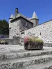
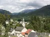
La Vigne Castle
| Municipality | Sainte-Eulalie |
|---|---|
| Postcode | 15140 |
| Latitude | 45.1191310 (N 45° 7’ 9”) |
| Longitude | 2.3757500 (E 2° 22’ 33”) |
| Altitude | From 560m to 828m |
| Surface area | 14.51 km² |
| Population | 234 inhabitants |
| Density | 16 inhabitants/km² |
| Prefecture | Aurillac (33 km, 35 min) |
| Insee code | 15186 |
| Intercommunality | CC du Pays de Salers |
| Department | Cantal |
| Territories | Auvergne, Massif Central |
| Region | Auvergne-Rhône-Alps |
| Saint-Martin-Valmeroux | 5 km (8 min) |
|---|---|
| Besse | 6.5 km (14 min) |
| Escorailles | 10.3 km (16 min) |
| Drugeac | 10.7 km (16 min) |
| Ally | 11.7 km (16 min) |
| Saint-Chamant | 11.7 km (14 min) |
| Salers | 12.2 km (16 min) |
| Saint-Martin-Cantalès | 12.2 km (21 min) |
| Fontanges | 12.8 km (20 min) |
| Saint-Paul-de-Salers | 13.6 km (22 min) |
| Saint-Bonnet-de-Salers | 13.7 km (20 min) |
| Pleaux | 15 km (21 min) |
| Chaussenac | 15.6 km (21 min) |
| Brageac | 16.5 km (23 min) |
| Last name | Activity type | Rate | City |
|---|---|---|---|
 | Nature and the great outdoors | 40 € to 75 € | Albepierre-Bredons (36 km) |
 | Sports sensations | 20 € | Lanobre (37 km) |
 | Sports sensations | 50 € to 350 € | Coltines (49 km) |
| Last name | Outing type | Difficulty | Duration | Departure municipality |
|---|---|---|---|---|
 | Village visit | Easy | 1:00 | Fontanges (10 km) |
 | Hike | Intermediate | 2:00 | Veyrières (25 km) |
 | Cycling itinerary | Athletic | 3:55 | Vic-sur-Cère (25 km) |
 | Cycling itinerary | Intermediate | 3:45 | Arpajon-sur-Cère (25 km) |
 | Hike | Intermediate | 3:05 | Saint-Jacques-des-Blats (28 km) |