


Favourite
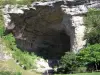
Mas d'Azil cave
| Municipality | Larbont |
|---|---|
| Postcode | 09240 |
| Latitude | 42.9940020 (N 42° 59’ 38”) |
| Longitude | 1.3974990 (E 1° 23’ 51”) |
| Altitude | From 409m to 722m |
| Surface area | 6.17 km² |
| Population | 63 inhabitants |
| Density | 10 inhabitants/km² |
| Prefecture | Foix (22 km, 23 min) |
| Insee code | 09154 |
| Intercommunality | CC Couserans-Pyrénées |
| Department | Ariège |
| Territories | Midi-Pyrénées, Pyrenees |
| Region | Occitanie |
| La Bastide-de-Sérou | 5 km (9 min) |
|---|---|
| Suzan | 8.1 km (13 min) |
| Montels | 8.7 km (13 min) |
| Nescus | 9.2 km (14 min) |
| Esplas-de-Sérou | 9.7 km (17 min) |
| Allières | 9.7 km (15 min) |
| Durban-sur-Arize | 10.3 km (15 min) |
| Castelnau-Durban | 11.1 km (13 min) |
| Cadarcet | 12.5 km (16 min) |
| Alzen | 12.6 km (18 min) |
| Montseron | 13.2 km (16 min) |
| Baulou | 14.3 km (17 min) |
| Montagagne | 14.4 km (24 min) |
| Sentenac-de-Sérou | 15.8 km (24 min) |
| Last name | Outing type | Difficulty | Duration | Departure municipality |
|---|---|---|---|---|
 | Hike | Easy | 4:00 | La Bastide-de-Sérou (3.2 km) |
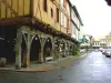
 | Village visit | Intermediate | 2:00 | Carbonne (36 km) |
| Village visit | Easy | 4:00 | Galey (40 km) |
 | Mountain bike itinerary | Intermediate | 8:00 | Mirepoix (40 km) |
 | Hike | Intermediate | 2:00 | Belloc (43 km) |