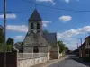
The Church of St. Martin, built in the 16th century, has the distinction of having a sundial installed in 1668.
Favourite
| Municipality | Hallivillers |
|---|---|
| Postcode | 80250 |
| Latitude | 49.7006760 (N 49° 42’ 2”) |
| Longitude | 2.2891550 (E 2° 17’ 21”) |
| Altitude | From 86m to 158m |
| Surface area | 7.12 km² |
| Population | 145 inhabitants |
| Density | 20 inhabitants/km² |
| Prefecture | Amiens (24 km, 30 min) |
| Insee code | 80407 |
| Intercommunality | CC Avre Luce Noye |
| Department | Somme |
| Territory | Picardy |
| Region | Hauts-de-France |
| Lawarde-Mauger-l'Hortoy | 1.5 km (3 min) |
|---|---|
| La Faloise | 4.1 km (6 min) |
| Chaussoy-Epagny | 4.3 km (10 min) |
| Fransures | 5.7 km (9 min) |
| Folleville | 7.4 km (12 min) |
| Rogy | 7.5 km (12 min) |
| Gouy-les-Groseillers | 8 km (14 min) |
| Flers-sur-Noye | 8 km (10 min) |
| Paillart | 8 km (12 min) |
| Esclainvillers | 8.2 km (16 min) |
| Bonneuil-les-Eaux | 8.4 km (11 min) |
| Quiry-le-Sec | 9 km (14 min) |
| Chirmont | 9.2 km (15 min) |
| Esquennoy | 9.4 km (11 min) |
The Church of St. Martin, built in the 16th century, has the distinction of having a sundial installed in 1668.
| Last name | Activity type | Rate | City |
|---|---|---|---|
 | Culture and education | 10 € to 450 € | Lassigny (42 km) |
 | Culture and education | 7 € | Compiègne (50 km) |
| Last name | Outing type | Difficulty | Duration | Departure municipality |
|---|---|---|---|---|
 | Hike | Easy | 2:00 | Paillart (6.1 km) |
 | Hike | Easy | 3:00 | Courcelles-sous-Moyencourt (22 km) |
| Hike | Intermediate | 4:00 | Courcelles-sous-Moyencourt (22 km) |
 | Village visit | Easy | 1:00 | Blangy-Tronville (22 km) |
| Cycling itinerary | Easy | 3:00 | Blangy-Tronville (22 km) |