Liven up your holidays!

Averton

Tourism, holidays & weekends guide in the Mayenne

Averton - Tourism, holidays & weekends guide in the Mayenne
8.0
3

Geographical information

MunicipalityAverton
Postcode53700
Latitude48.3328879 (N 48° 19’ 58”)
Longitude-0.2255310 (W 0° 13’ 32”)
AltitudeFrom 124m to 292m
Surface area40.62 km²
Population573 inhabitants
Density14 inhabitants/km²
PrefectureLaval (66 km, 1:05)
Insee code53013
IntercommunalityCC du Mont des Avaloirs
DepartmentMayenne
TerritoryMaine
RegionPays de la Loire

Nearest cities & towns

Courcité4 km (7 min)
Saint-Aubin-du-Désert4.4 km (5 min)
Villaines-la-Juhel4.6 km (6 min)
Saint-Mars-du-Désert7.7 km (10 min)
Saint-Thomas-de-Courceriers8 km (14 min)
Saint-Germain-de-Coulamer9.6 km (14 min)
Saint-Paul-le-Gaultier9.6 km (9 min)
Loupfougères9.9 km (12 min)
Crennes-sur-Fraubée10 km (11 min)
Gesvres10.1 km (12 min)
Trans10.3 km (14 min)
Saint-Georges-le-Gaultier12.6 km (14 min)
Champgenéteux13 km (12 min)
Villepail13.6 km (15 min)

Things to see and do

The church is dedicated to the Virgin and Saint Roch not yet venerated in the parish. Of Roman origin, the church was renovated in the 16th century the choir and has three altarpieces of the 16th century including the high altar depicting the Assumption of the Virgin.

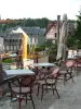
Averton also owns the pond Pearl, around which are games, picnic areas, fishing lodges and a BMX track.

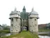
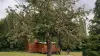
It is also a well sixteenth, granite, which belonged to the lords of the castle which Averton disappeared.

Pond fishing in the pond Pearl.

Photos

View from the village road to the chapel
See photo
Detail road to the chapel of the Pont Neuf
See photo
Plants
Plants
See photo

Weather

Friday 10 may
Min. 11°C - Max. 22°C
Day
Night
Saturday 11 may
Min. 12°C - Max. 23°C
Day
Night
Sunday 12 may
Min. 13°C - Max. 20°C
Day
Night

Visits, leisure and activities nearby

Leisure activities

Last nameActivity typeRateCity
Private spa in a tropical environment
Well-being60 € to 150 € Bagnoles de l'Orne Normandie (29 km)

Outings

Last nameOuting typeDifficultyDurationDeparture municipality
Pays Domfrontais
Cycling itineraryIntermediate5:00Soucé (36 km)
The greenway of Saosnois: a territory to discover!
HikeEasy3:25Saint-Longis (43 km)
Beef Road
HikeEasy3:45Jauzé (47 km)
Around Lande Pourrie
Car itineraryEasy4:00Saint-Cyr-du-Bailleul (50 km)
Discovering Bonnétable
HikeEasy55 minBonnétable (51 km)

Restaurants

Bed & breakfasts

Vacation rentals

Campsites

Hotels

Your holidays
A hotel
A vacation rental
A bed & breakfast
A campsite
A leisure activity
A restaurant
A rental car
A plane ticket
By continuing to browse our site, you are agreeing to the use of cookies to improve your experience and make targeted offers.
Find out more and make settings
Your account