Liven up your holidays!

Allemans

Tourism, holidays & weekends guide in the Dordogne

Geographical information

MunicipalityAllemans
Postcode24600
Latitude45.2879230 (N 45° 17’ 17”)
Longitude0.3087570 (E 0° 18’ 32”)
AltitudeFrom 47m to 167m
Surface area18.75 km²
Population522 inhabitants
Density27 inhabitants/km²
PrefecturePérigueux (42 km, 45 min)
Insee code24007
IntercommunalityCC du Périgord Ribéracois
DepartmentDordogne
TerritoriesAquitaine, Périgord
RegionNew-Aquitaine

Nearest cities & towns

Comberanche-et-Épeluche3.4 km (8 min)
Bertric-Burée4.8 km (8 min)
Saint-Paul-Lizonne6.2 km (9 min)
Saint-Séverin6.3 km (7 min)
Villetoureix6.8 km (9 min)
Ribérac6.8 km (9 min)
Bourg-du-Bost8.2 km (11 min)
Coutures8.9 km (13 min)
Lusignac8.9 km (12 min)
Saint-Martin-de-Ribérac9.1 km (12 min)
Verteillac9.9 km (12 min)
Petit-Bersac10.4 km (12 min)
Montignac-le-Coq10.8 km (11 min)
Chassaignes10.9 km (15 min)

Things to see and do

Places of interest

Monuments

Events and festivities

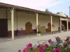
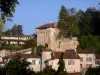
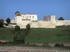
Châteaux en Fête - Château Le Mas de Montet

Weather

Sunday 28 april
Min. 7°C - Max. 16°C
Day
Night
Monday 29 april
Min. 6°C - Max. 19°C
Day
Night
Tuesday 30 april
Min. 10°C - Max. 19°C
Day
Night

Visits, leisure and activities nearby

Leisure activities

Last nameActivity typeRateCity
Sightseeing cruise in the Venice of Périgord
Entertainment7 € to 10 € Brantôme en Périgord (28 km)
Comille Aventure treetop adventure park
Sports sensations20 € Cornille (38 km)
Tasting and sales at the Borderie vineyards
Local flavoursFreeSaint-Médard-de-Guizières (42 km)
Guîtres-Marcenais Tourist Train
Nature and the great outdoors15 € Guîtres (48 km)
Pays Gabay o Guîtres railbike
Nature and the great outdoors35 € Guîtres (48 km)

Outings

Last nameOuting typeDifficultyDurationDeparture municipality
Loop of Vendoire
HikeEasy2:30Vendoire (14 km)
Loop by the King of Chauzes Cross Rat
HikeEasy4:00Paussac-et-Saint-Vivien (19.3 km)
Ancient loop Paussac Saint-Just
HikeEasy4:00Paussac-et-Saint-Vivien (19.3 km)
Banks of the Isle River
Cycling itineraryEasy4:00Trélissac (38 km)
Saint-Michel d'Auberoche Chapel
HikeIntermediate4:00Antonne-et-Trigonant (42 km)

Restaurants

Bed & breakfasts

Vacation rentals

Campsites

Hotels

Your holidays
A hotel
A vacation rental
A bed & breakfast
A campsite
A leisure activity
A restaurant
A rental car
A plane ticket
By continuing to browse our site, you are agreeing to the use of cookies to improve your experience and make targeted offers.
Find out more and make settings
Your account