Itinerary from the Siagne valley to Tignet.
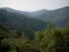
The Tanneron Massif
Itinerary from the Siagne valley to Tignet.

| Department | Alpes-Maritimes |
|---|---|
| Departure municipality | Le Tignet |
| Outing type | Hike |
| Difficulty | Intermediate |
| Duration | 2:30 |
| Recommended period | from january to december |
| Environment | Countryside |
| Kilometres | 7 km |
| Altitude upon departure | 250m |
| Change in altitude | 230m |
At "Val du Tignet" make your way towards "Quartier de l'Istre" and the car park opposite the school.
From the car park, follow signs to the Traverse des Planasteaux then take Chemin de Grosse Colle on the right. Walk down through the pine trees. Cross the old railway line. Continue along a path through the vegetation to the banks of the Siagne river. Follow the "Saint-Cassien" path which passes the pillar of an old railway viaduct. At the Lignière footbridge, cross the Attelée valley and follow a path up the valley. Leave this path after 1.5 km and descend on the left. Cross the valley again. Make your way up the opposite slope through a forest of mimosa. Make your way to a trail that soon joins the path you followed at the start of the walk.