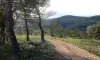
From the parking lot, heading left towards the Place Paul Valery. Continue down the street Anatole France, then in the neighborhood Sergognes. After a curve to the right, the road opens a wide vehicle track; go left. The trail leaves the village and comes to a fork; continue left to a small pass.
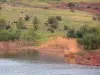
Then go right onto a dirt road and continue for about 500 meters, you have a view of Nébian the Pic Saint-Loup and the Hérault Valley.
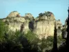
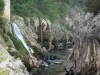
A few meters before the platform, climb right in the middle of the terraces (high rise) and appointed by stairs join the board. Arriving at the top of the rock Cayla, overlooking the valley of Dourbie (picnic table). Continue amid the oaks to reach an intersection.
Continue on the path, cross a fence and go right to the highest point of the course (Table interpretation and view of the peak Vissou, the village of Villeneuvette and Caroux). Go down, go to the fork at a pine forest. Turn left and pass a capitelle. Leave the track and get across to a crossroads.
Turn right onto another track near an inert deposit. Cut the track and get in front following good markup on a trail in the valley and reach a paved road.
Go right and down to the village. At the entrance, go left towards the Place Gambetta, go down the steps to the Freedom Square, passing under a harrow. Turn left, then right, cross a small roundabout. Continue Republic Street, past the town hall, then go right into the parking space Pierre Laroque.