Through that Honore de Balzac called "one of the most beautiful valleys of Touraine", we take you through the old path of Azay existed since the Middle Ages, probably serving strategic locations for the time, especially marked by Norman invasions and the hundred years war which succeeded it.
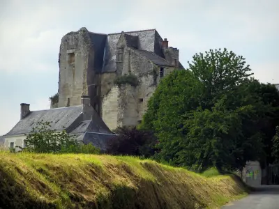
The clod of Robin castle, located in Pont-de-Ruan, testifies to these pages of history of France particularly disorders. It rises to over 40 m level of the Indre passing below: privileged vantage point that so dominates the entire valley. Count of Anjou, known as "black prince" Fulk Nerra (tenth century) made fortify this rocky mound, making it perform sophisticated underground refuges on 3 levels, communicating with the river and numerous galleries that dot the hillside, probably to the castle of Goatherd, not far away. Many of these are now éboulés underground or recapped because of their dangerousness.
This valley portion above a ford / large tray, below the green mill (hamlet bass goatherd) which doubled that of Pont-de-Ruan, upstream. The latter, located on an old Gallo-Roman way coinciding with the Pilgrim, was often overloaded. One may think that this whole area, including the mills, were sheltering small economic structures of the type relay station, farrier, inn, commerce, coveted by many brigands in the region and the passing soldiery.
Let's go a little further, a century later... with the implementation of the Priory of Relay (Pont-de-Ruan) by Bertrand Arbrissel, himself a founder of the Abbey of Fontevrault. This mixed priory (Order of Saint Benedict) lasted until the eighteenth century when it was destroyed and sold later as national property during the Revolution... to finally be transformed into farm! Everything seems to ruin.. and yet there is still the home of the Abbess, a beautiful medieval dovecote and - a rarity - a private church dedicated. The owners, brave and fierce, undertake rehabilitation of the site with the help of volunteers and will organize cultural events related to the heritage of the valley of the Indre. Places are private but can be visited by appointment.
You can make this bike path until the end of the ride, but also drive for 2 km, then on foot.
From Alexander Calder instead to Saché (town hall), take the direction of Druyes. Roll on the three bridges. At the stop sign, turn right and go straight for 300 meters, towards Artannes sur Indre, by the D84 road. Park just outside the hamlet of Lower Goatherd, you just cross, on the small parking lot on the left, at the foot of the rock wall.
You are in the valley of the Indre, between high tufa stone embankment, dense forest and the river... There is little room to park car and shoulders are furniture! The speed limit but beware by tightening the left and you are reporting. You are on the road to Indre bike, but also on the tour Tour de France 1957 and cyclists are often at full speed on the descent!
All along the hillside is pierced by numerous excavations where the tufa stone were once mined for the construction of numerous castles of the region. Most of these caves were inhabited; many vestiges testify: remains of houses, fireplaces, metal doors, bars on windows. Most of the time we are accolait a house and the excavated portion served chamber (13 ° constant). Warning do not get too close because there is often very loose scree of rocks.
After around 400 m... the bank takes height, peaking sharply to 40 m... You are at the foot of Defence clod of "Château Robin." The wall is vertical, pierced with holes. The place seems inhospitable: go there quickly... the place is haunted, according to an old local legend. After 250 m, at the top of the hill, turn sharply to the left, leaving a great view of the manor Vonnes (XV. C.), A bucolic valley.
Climb the small road for 200 meters and then commit yourself on the beautiful rider crossed driveway. You will quickly see to your left, the foothills of the hillock culminating defense again and the rest of flukes (private area). After 250m, turn right onto the forest road (muddy) and go straight due west for 900 m. You then descend into a deep valley. On the left side of the trail stand of large mossy stones walls collapsed remains of an old property. Enjoy the silence you enter the grounds of the Priory of Relay (eleventh century). Go along high walls in ruins to your left and you agree on the sunken road for 70 m; you arrive at the foot of a large monumental stone portal (seventeenth century) whose facade is carved: probable remains of the ancient city wall of the priory. We see, in fact, an old bread oven and left what was once a church, now rehabilitated and some residential houses.
Retrace your steps. Take a break in this valley that has kept a certain magic... Take the forest road that goes up. After 500 m, in the crossroads crossed panels, take the left path down to another valley. Make 200 m and you arrive at the theater barn Vaugarni. Turn right and take the paved road that takes you back to the RD 84 (800 m). Enjoy again the beautiful view of the manor Vonnes during almost the entire route. Turn right to return to Saché, a distance of 2.5 km or the car park (800m).