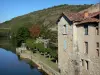
From the heights of the valley and from villages to villages, access stunning views of the Quercy hillsides. This itinerary, dotted with local produce farms, will take you to the source of the Bonnette, in Puylagarde, a lookout village, to reach Caylus by Lacapelle-Livron. TIPS TO VOYAGEURS - The 12 routes proposed on the nature pole are structured around the site of the Aveyron Gorge, backbone between several landscape features, gorges, causses of the Quercy and Terrefort du Rouergue. It was the basement that determined the landscapes and activities of men. Traveling through a land of art and history, these itineraries invite you to go back in time. Whether your sensibility is related to local history, geology, spiritual or naturalistic, these routes are an invitation to document yourself upstream to appreciate what your senses will travel. In the past, 30,000 people lived here testifying to important activity centres. Water, mills, phosphate that went as far as England, droppings, hides, livestock, toll bridges, dryers, all the savings and trades that made the wealth of this territory, will indulge on the way. Along the water that crosses the limestone plateaus to feed the mills of the Bonnette valley, thermalism until 1930, and today the practices of activities of nature, the country gives to see the time. Today, 7,500 people live in this same territory and bring to life the know-how of quality terroirs and a conviviality shared in a very unspoiled nature, enjoy.... These routes are passable all year round subject to the opening of certain sites. In the hot hours, make a cut in the shade and hit the road again at the end of the day. Be foresighted and carry enough water. Bring your garbage with you!

Caylus