Liven up your holidays!
Destination
State your preferences
Guide
Plan your stay
Your account
English
Français
Deutsch
Italiano
Español
Nederlands
Português
Русский
简体中文
日本語
0
0
0
Great East
Menu
Tourism
Gastronomy
Outings
Activities
Events
Restaurants
Hotels
Vacation rentals
Bed & breakfasts
Campsites
Holiday insurance
Rental car
Train tickets
Plane tickets
Transfers
Holiday insurance
Holiday insurance
French courses
Romantic weekend
Family weekend
Cheap weekend
Unusual weekend
Find my position
Confirm
Discover
Tourist sites
Gastronomy
Cities & towns
Tourism labels
Themed itineraries
Custom itineraries
Photos
Panoramas
Tourism quiz
Going out
Leisure activities
Outings
Events
Restaurants
Stay
Hotels
Bed & breakfasts
Vacation rentals
Campsites
Travel
Rental car
Train tickets
Plane tickets
Holiday insurance
Information sheets
French courses
Outings
Great East
Outings in Great East
Ideas for walks and hikes in Great East
Search
Cancel
227
outings found
Great East
Change
Sort by difficulty
Sort by change in altitude
Sort by duration
Sort by length in kilometres
Filter results
Open map
Outing type
Hike
Cycling itinerary
Horse ride
Other means of transport
Difficulty
Easy
Intermediate
Athletic
Change in altitude
Less than 200 m
from 200 m to 500 m
from 500 m to 1000 m
More than 1000 m
Duration
Less than 2 h
from 2 h to 4 h
More than 4 h
Kilometres
Less than 5 km
from 5 km to 10 km
from 10 km to 20 km
More than 20 km
Territory
Alsace
Champagne-Ardenne
Lorraine
Filter results
Hide filters
Open map
Hide map
Outings in Great East
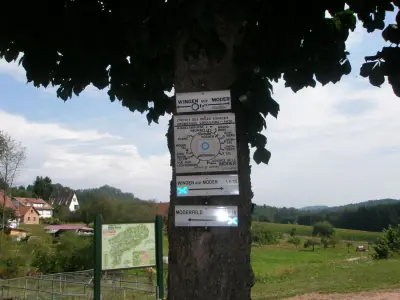
Altorf discovery trail
5.0
4
Village visit in Altorf
Easy
1:30, 1 km (change in altitude 0m)
Discover the historical heritage of Altorf. Outstanding monuments and architectural curiosities around the old 12th century Benedictine abbey church of Saint-Cyriaque.
Favourite
Itinerary
Pâquis Loop
7.5
6
Hike in Vouziers
Easy
2:30, 6 km (change in altitude 0m)
Walk at the gateway to Vouziers to discover this small country town.
Favourite
Itinerary
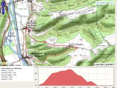
Around Autigny
9.2
5
Hike in Autigny-le-Petit
Easy
1:45, 6 km (change in altitude 135m)
About a two-hour walk which will offer you the opportunity to admire the valley from above. Route also possible for mountain bikes.
Favourite
Itinerary
Grand Ventron
6.8
12
Hike in Ventron
Intermediate
2:30, 15 km (change in altitude 572m)
A path that winds through the forest, where you will pass close to a lake, a ferruginous spring, to arrive at the highest point in the village at an altitude of 1,204 m, with a view over some of the Vosges summits, such as the Markstein, the…
Favourite
Itinerary
Tour of Escherbruch Lake
6.6
9
Hike in Ham-sous-Varsberg
Easy
30 min, 2 km (change in altitude 0m)
Discover the fauna and flora of the "Marsh Path" around Escherbruch Lake.
Favourite
Itinerary
Erstein Polder
6.4
5
Hike in Gerstheim
Easy
4:00, 20 km (change in altitude 6m)
Do you want to discover the Grand Ried on horseback? Experience the treasures of the landscapes and the varied plant and animal life? The Grand Ried is characterised by presence of water. Pass through a nature reserve with black poplars, hornbeam…
Favourite
Itinerary
Villey-Saint-Étienne structures
7.4
4
Hike in Villey-Saint-Étienne
Easy
2:00, 7 km (change in altitude 0m)
This 7-kilometre itinerary, green signposting, brings you close to the main military structures in Villey-Saint Villey-Saint-Étienne Forest: Vieux Canton Fort, the Nibarde Shelter or the Bas du Chêne structure, all built between 1890 and 1909.
Favourite
Itinerary
Mont Saint-Jean Mountain Circuit
7.6
5
Hike in Jeandelaincourt
Easy
2:00, 5 km (change in altitude 161m)
The calcareous grassland which occupies a large part of the site offers a varied plant life typical of this type of grassland. The juxtaposition of open environments and groups of shrubs enables the presence of many birds and insects. Saint-jean…
Favourite
Itinerary
Tour of Mount Saint-Jean
6.8
9
Hike in Solbach
Easy
1:00, 4 km (change in altitude 137m)
Walk of around 1 hour, easy and accessible to all. From the Perheux Pass (699 m), you can enjoy a wonderful view!
Favourite
Itinerary
Panoramic walk
9.0
3
Hike in Orcevaux
Easy
1:00, 3 km (change in altitude 0m)
Small walk to discover the beautiful village of Orcevaux, as well as a beautiful point of view.
Favourite
Itinerary
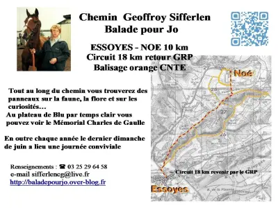
Walk for Jo - Geoffroy Sifferlen Path
9.4
14
Hike in Noé-les-Mallets
Easy
4:00, 16 km (change in altitude 160m)
Chemin Geoffroy Sifferlen - Stroll for Jo: Departure from Noé or Essoyes (town hall squares) or from the Plateau de Blu. Orange markup (CNTE) with panels on the local flora and fauna. Pleasant 16 km circuit (returning by the GRP) and variants…
Favourite
Itinerary
8.6
8
Hike in Zittersheim
Athletic
4:20, 13 km (change in altitude 416m)
Favourite
Itinerary
8.4
3
Hike in Vaudémont
Easy
7:35, 28 km (change in altitude 212m)
Favourite
Itinerary
8.7
6
Hike in Pont-à-Mousson
Easy
1:20, 5 km (change in altitude 26m)
Favourite
Itinerary
8.0
3
All-terrain bike itinerary in Nogent-sur-Seine
Intermediate
4:45, 70 km (change in altitude 571m)
Favourite
Itinerary
8.0
3
All-terrain bike itinerary in Villenauxe-la-Grande
Athletic
4:35, 66 km (change in altitude 638m)
Favourite
Itinerary
8.3
5
All-terrain bike itinerary in Bayel
Athletic
3:55, 53 km (change in altitude 863m)
Favourite
Itinerary
9.2
3
All-terrain bike itinerary in Marcilly-le-Hayer
Athletic
5:50, 83 km (change in altitude 991m)
Favourite
Itinerary
9.0
4
All-terrain bike itinerary in Ervy-le-Châtel
Athletic
5:15, 75 km (change in altitude 870m)
Favourite
Itinerary
8.7
3
All-terrain bike itinerary in Mussy-sur-Seine
Athletic
5:40, 78 km (change in altitude 1233m)
Favourite
Itinerary
9.2
5
All-terrain bike itinerary in Essoyes
Athletic
4:40, 64 km (change in altitude 980m)
Favourite
Itinerary
9.2
3
All-terrain bike itinerary in Bar-sur-Aube
Athletic
4:20, 59 km (change in altitude 928m)
Favourite
Itinerary
8.8
5
All-terrain bike itinerary in Soulaines-Dhuys
Athletic
4:05, 58 km (change in altitude 710m)
Favourite
Itinerary
9.4
2
All-terrain bike itinerary in Vendeuvre-sur-Barse
Easy
4:50, 69 km (change in altitude 768m)
Favourite
Itinerary
8.6
6
All-terrain bike itinerary in Dienville
Easy
1:30, 22 km (change in altitude 195m)
Favourite
Itinerary
Outings
1
2
3
4
5
6
>>
See more results
By continuing to browse our site, you are agreeing to the use of cookies to improve your experience and make targeted offers.
Find out more and make settings
Close
Your account
Continue with my email