This circuit, particularly attractive for children, partly follows the path of discovery (weather station, lapiaz...) and allows to discover the vast panorama of the Alps. Link to the guidebook
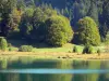
Nantua Lake


This circuit, particularly attractive for children, partly follows the path of discovery (weather station, lapiaz...) and allows to discover the vast panorama of the Alps. Link to the guidebook
| Department | Ain |
|---|---|
| Departure municipality | Haut Valromey |
| Outing type | Hike |
| Difficulty | Intermediate |
| Duration | 3:20 |
| Kilometres | 10 km |
| Altitude upon departure | 1034m |
| Change in altitude | 309m |
Depart from the town of Haut Valromey, latitude 46.0387300 (N 46° 2’ 19”), longitude 5.7006800 (E 5° 42’ 2”)