Liven up your holidays!
Destination
State your preferences
Guide
Plan your stay
Your account
English
Français
Deutsch
Italiano
Español
Nederlands
Português
Русский
简体中文
日本語
0
0
0
Avillers
Menu
Tourism
Gastronomy
Outings
Activities
Events
Restaurants
Hotels
Vacation rentals
Bed & breakfasts
Campsites
Holiday insurance
Rental car
Train tickets
Plane tickets
Transfers
Holiday insurance
Holiday insurance
French courses
Romantic weekend
Family weekend
Cheap weekend
Unusual weekend
Find my position
Confirm
Discover
Tourist sites
Gastronomy
Cities & towns
Tourism labels
Themed itineraries
Custom itineraries
Photos
Panoramas
Tourism quiz
Going out
Leisure activities
Outings
Events
Restaurants
Stay
Hotels
Bed & breakfasts
Vacation rentals
Campsites
Travel
Rental car
Train tickets
Plane tickets
Holiday insurance
Information sheets
French courses
Outings
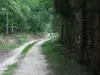
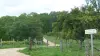
Around Avillers
Outings in Avillers
Ideas for walks and hikes in Avillers
Search
Cancel
34
outings found
Avillers
Change
Adjust destination
Town centre of Avillers
Locality - Former locality Oncourt (Thaon-les-Vosges)
Locality - Former locality Thaon-les-Vosges (Thaon-les-Vosges)
Transport - Airport of Épinal - Mirecourt (Juvaincourt)
Transport - Train station of Charmes (Charmes)
Transport - Train station of Charmes (Essegney)
Transport - Train station of Châtel - Nomexy (Nomexy)
Transport - Train station of Diarville (Housséville)
Transport - Train station of Hymont - Mattaincourt (Hymont)
Transport - Train station of Igney (Igney)
Transport - Train station of Mirecourt (Mirecourt)
Transport - Train station of Praye-sous-Vaudémont (Praye)
Transport - Train station of Thaon (Thaon-les-Vosges)
Transport - Train station of Vincey (Vincey)
Information point - Tourist Office of Charmes (Charmes)
Information point - Tourist Office of Saxon-Sion (Saxon-Sion)
Information point - Tourist Office of the Pays de Mirecourt (Mirecourt)
Leisure centre - Ecomuseum of the Battant (Charmes)
Leisure centre - Museum of La Lutherie et de l'Archèterie (Mirecourt)
Leisure centre - Museum of the Musique Mécanique (Mirecourt)
Monument - Basilica Notre-Dame de Sion (Saxon-Sion)
Monument - Basilica Saint-Pierre-Fourier (Mattaincourt)
Monument - Castle of Bainville-aux-Miroirs (Bainville-aux-Miroirs)
Monument - Castle of Haroué (Haroué)
Monument - Church Saint-Martin (Vomécourt-sur-Madon)
Monument - Church Saint-Paul (Gorhey)
Monument - Church Saint-Rémi (Remoncourt)
Monument - Fortress of Châtel-sur-Moselle (Châtel-sur-Moselle)
Monument - Military Cemetery of the Commonwealth (Charmes)
Performance hall - La Rotonde (Thaon-les-Vosges)
Sort by distance from starting point
Sort by difficulty
Sort by change in altitude
Sort by duration
Sort by length in kilometres
Filter results
Open map
Outing type
Hike
Cycling itinerary
Horse ride
Other means of transport
Distance from starting point
Less than 10 km
from 10 km to 30 km
More than 30 km
Difficulty
Easy
Intermediate
Athletic
Change in altitude
Less than 200 m
from 200 m to 500 m
from 500 m to 1000 m
More than 1000 m
Duration
Less than 2 h
from 2 h to 4 h
More than 4 h
Kilometres
Less than 5 km
from 5 km to 10 km
from 10 km to 20 km
More than 20 km
Territory
Champagne-Ardenne
Franche-Comté
Lorraine
Filter results
Hide filters
Open map
Hide map
Outings in Avillers
Outings around Avillers
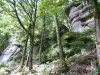
Circuit of the Cross of Virine
9.0
4
Hike in Circourt
Easy
4:30, 16 km (change in altitude 100m)
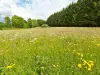
Nice walk through forests and with magnificent views of the village of Circourt. Circuit marked by a red disk on a white background.
Located
8.6 km
away of Avillers
Favourite
Itinerary
Vines and steeples
5.7
3
Hike in Charmes
Intermediate
5:00, 16 km (change in altitude 100m)
Panoramic trail offering magnificent views of the Moselle valley (canal, river, small villages' heritages...)
Located
9.4 km
away of Avillers
Favourite
Itinerary
Circuit of the sector Dompaire - Madonne and Lamerey
8.0
1
Hike in Dompaire
Intermediate
3:00, 14 km (change in altitude 200m)
Follow the markings with green, blue and red discs.
Located
10.2 km
away of Avillers
Favourite
Itinerary
8.4
3
Hike in Vaudémont
Easy
7:35, 28 km (change in altitude 212m)
Located
14.9 km
away of Avillers
Favourite
Itinerary
Circuit of Chaumoussey
8.0
1
Hike in Chaumousey
Easy
4:00, 15 km (change in altitude 50m)
Stroll along the shores of Lake Bouzey and discover wonderful wooded landscapes and beautiful forests.
Located
18 km
away of Avillers
Favourite
Itinerary
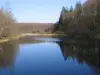
Bouzey Lake and Comtesse Lake
8.2
21
Hike in Renauvoid
Easy
2:30, 8 km (change in altitude 0m)
A beautiful and easy walk around the lake.
Located
23 km
away of Avillers
Favourite
Itinerary
Source of the Avière
6.8
4
Hike in Renauvoid
Easy
1:45, 6 km (change in altitude 232m)
Rural and hilly forest trail through the surroundings of Renauvoid.
Located
23 km
away of Avillers
Favourite
Itinerary
Around Uzéfaing
4.8
5
Hike in Épinal
Easy
3:00, 8 km (change in altitude 175m)
Pleasant and well shaded forest itinerary dominating the hamlet of Uzéfaing.
Located
24 km
away of Avillers
Favourite
Itinerary
Grands Bois Circuit
7.5
17
Hike in Épinal
Easy
4:00, 13 km (change in altitude 100m)
Shady walk in Épinal Forest, home to many outstanding trees and sites.
Located
24 km
away of Avillers
Favourite
Itinerary
Saint-Laurent Hills
7.6
11
Hike in Épinal
Easy
3:00, 12 km (change in altitude 300m)
Well shaded forest walk with viewpoints.
Located
24 km
away of Avillers
Favourite
Itinerary
Tour of Bambois
7.1
3
Hike in Épinal
Easy
3:00, 10 km (change in altitude 0m)
Easy circuit on a forest path which passes close to Bambois Fort.
Located
24 km
away of Avillers
Favourite
Itinerary
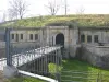
Forts Circuit
6.1
9
Hike in Épinal
Easy
2:30, 8 km (change in altitude 0m)
From Uxegney Fort through the villages of Domèvre-sur-Avière and Uxegney via Bois l'Abbé.
Located
24 km
away of Avillers
Favourite
Itinerary
Dix Trail
7.8
15
Hike in Épinal
Easy
3:00, 10 km (change in altitude 321m)
Pleasant urban itinerary over the hills and the forests of Lower Vosges, with magnificent viewpoints over the town.
Located
24 km
away of Avillers
Favourite
Itinerary
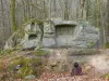
Olima Rocks
8.2
12
Hike in Épinal
Easy
3:00, 11 km (change in altitude 150m)
Shaded forest trail following the Bouzey supply canal and part of the old railway line which served the fortified outskirts of Épinal.
Located
24 km
away of Avillers
Favourite
Itinerary
Eastern Feigne Circuit
7.9
8
Hike in Deyvillers
Easy
2:30, 8 km (change in altitude 0m)
Pleasant hilly walk through the Deyvillers Forest.
Located
26 km
away of Avillers
Favourite
Itinerary
Solitary Bonneval
6.6
7
Hike in Relanges
Easy
2:00, 6 km (change in altitude 0m)
Tour of Relanges with its 12th century Romanesque church, then through the forest where you will be able to discover Belle Roche, and a few hundred metres further on, the old chapel of Bonneval. It is possible to enjoy a guided tour with a local…
Located
27 km
away of Avillers
Favourite
Itinerary
The Charmoise
8.5
2
Hike in Charmois
Easy
3:30, 13 km (change in altitude 60m)
A beautiful walk that alternates village, fields, forest and sensitive natural area.
Located
28 km
away of Avillers
Favourite
Itinerary
The Tops of Vigneulles
9.0
2
Hike in Vigneulles
Easy
1:30, 5 km (change in altitude 37m)
A nice walk in the middle of mirabelliers proposed by the club Vosges.
Located
29 km
away of Avillers
Favourite
Itinerary
Coughing wood
9.0
3
Hike in Blainville-sur-l'Eau
Easy
2:00, 8 km (change in altitude 45m)
An invitation from the Vosges club "air as a hike", associated with the community of communes, to discover a heritage, fauna, flora and landscapes that surround Blainville.
Located
31 km
away of Avillers
Favourite
Itinerary
8.4
1
Hike in La Vôge-les-Bains
Intermediate
2:10, 7 km (change in altitude 134m)
Located
35 km
away of Avillers
Favourite
Itinerary
9.6
5
Hike in Docelles
Easy
50 min, 3 km (change in altitude 19m)
Located
36 km
away of Avillers
Favourite
Itinerary
9.7
4
Hike in Neufchâteau
Easy
1:55, 6 km (change in altitude 146m)
Located
38 km
away of Avillers
Favourite
Itinerary
6.0
2
Hike in Bruyères
Easy
50 min, 3 km (change in altitude 2m)
Located
40 km
away of Avillers
Favourite
Itinerary
8.5
4
Hike in Maxey-sur-Meuse
Intermediate
3:20, 11 km (change in altitude 218m)
Located
41 km
away of Avillers
Favourite
Itinerary
The Pissoire Waterfall and Le Haut du Tôt Church
8.4
12
Village visit in Le Tholy
Easy
4:00, 22 km (change in altitude 200m)
A journey through various landscapes, fields, mountains, forest and the Pissoire Waterfall, before arriving at Le Haut du Tôt, which has the tallest church in Vosges. The whole itinerary is marked.
Located
47 km
away of Avillers
Favourite
Itinerary
See more results
By continuing to browse our site, you are agreeing to the use of cookies to improve your experience and make targeted offers.
Find out more and make settings
Close
Your account
Continue with my email