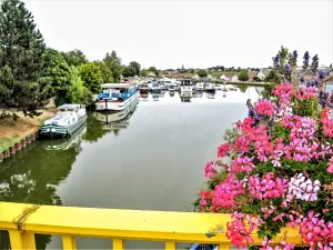
The relay boating on the Canal du Rhône au Rhin.
The laundry on the Largue.


| Municipality | Wolfersdorf |
|---|---|
| Postcode | 68210 |
| Tourism label | ") |
| Latitude | 47.6449100 (N 47° 38’ 42”) |
| Longitude | 7.1076650 (E 7° 6’ 28”) |
| Altitude | From 287m to 348m |
| Surface area | 3.66 km² |
| Population | 377 inhabitants |
| Density | 103 inhabitants/km² |
| Prefecture | Colmar (67 km, 53 min) |
| Insee code | 68378 |
| Intercommunality | CC Sud Alsace Largue |
| Department | Haut-Rhin |
| Territory | Alsace |
| Region | Great East |
| Traubach-le-Bas | 1.4 km (2 min) |
|---|---|
| Dannemarie | 2.4 km (4 min) |
| Retzwiller | 2.9 km (6 min) |
| Traubach-le-Haut | 3.2 km (4 min) |
| Elbach | 3.7 km (8 min) |
| Manspach | 4.3 km (7 min) |
| Gommersdorf | 4.4 km (9 min) |
| Buethwiller | 4.9 km (10 min) |
| Guevenatten | 5.1 km (7 min) |
| Bréchaumont | 5.1 km (7 min) |
| Hagenbach | 5.7 km (7 min) |
| Altenach | 5.8 km (9 min) |
| Ballersdorf | 5.8 km (8 min) |
| Valdieu-Lutran | 6.1 km (11 min) |
| Falkwiller | 6.7 km (8 min) |
The relay boating on the Canal du Rhône au Rhin.
The laundry on the Largue.


| Last name | Activity type | Rate | City |
|---|---|---|---|
 | Culture and education | 11 € | Le Thillot (36 km) |
 | Arts and Crafts | 12 € | Basse-sur-le-Rupt (47 km) |
| Last name | Outing type | Difficulty | Duration | Departure municipality |
|---|---|---|---|---|
 | Hike | Intermediate | 1:00 | Burnhaupt-le-Haut (9.9 km) |
 | Village visit | Easy | 1:00 | Masevaux-Niederbruck (16.5 km) |
 | Hike | Intermediate | 3:00 | Masevaux-Niederbruck (16.9 km) |
 | Hike | Intermediate | 1:05 | Thann (18.5 km) |
 | Hike | Intermediate | 2:30 | Kirchberg (20 km) |