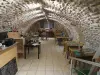
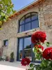
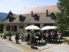
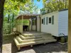
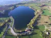
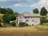
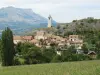
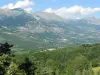
Bordered by the Durance and extending to Ceüzette, the territory of the municipality of Vitrolles, made up of several hamlets, is dominated by the peak of Crigne which rises to 1263 meters.

Favourite
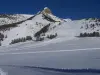
Bordered by the Durance and extending to Ceüzette, the territory of the municipality of Vitrolles, made up of several hamlets, is dominated by the peak of Crigne which rises to 1263 meters.
| Municipality | Vitrolles |
|---|---|
| Postcode | 05110 |
| Latitude | 44.4346580 (N 44° 26’ 5”) |
| Longitude | 5.9492570 (E 5° 56’ 57”) |
| Altitude | From 545m to 1455m |
| Surface area | 14.62 km² |
| Population | 218 inhabitants |
| Density | 14 inhabitants/km² |
| Prefecture | Gap (26 km, 29 min) |
| Insee code | 05184 |
| Intercommunality | CA Gap-Tallard-Durance |
| Department | Hautes-Alpes |
| Territories | Alps, Dauphiné |
| Region | Provence-Alps-French Riviera |
| Barcillonnette | 4.2 km (8 min) |
|---|---|
| Lardier-et-Valença | 4.3 km (7 min) |
| Esparron | 7.2 km (12 min) |
| Monêtier-Allemont | 7.2 km (10 min) |
| La Saulce | 7.8 km (11 min) |
| Claret | 10.2 km (16 min) |
| Fouillouse | 10.2 km (18 min) |
| Sigoyer | 11.4 km (20 min) |
| Ventavon | 12.1 km (16 min) |
| Curbans | 12.4 km (17 min) |
| Tallard | 14.2 km (16 min) |
| Lettret | 15.1 km (18 min) |
| Melve | 15.7 km (25 min) |
| Thèze | 16.2 km (21 min) |
| Last name | Activity type | Rate | City |
|---|---|---|---|
 | Nature and the great outdoors | 200 € to 1100 € | Ancelle (29 km) |
 | Nature and the great outdoors | 50 € to 375 € | Éourres (32 km) |
 | Sports sensations | 44 € | Ubaye-Serre-Ponçon (32 km) |
 | Local flavours | Free | Noyers-sur-Jabron (32 km) |
 | Arts and Crafts | 30 € | Saint-Vincent-sur-Jabron (34 km) |
| Last name | Outing type | Difficulty | Duration | Departure municipality |
|---|---|---|---|---|
 | Hike | Easy | 3:00 | La Bâtie-Vieille (21 km) |
 | Hike | Intermediate | 5:00 | La Bâtie-Vieille (21 km) |
 | Hike | Intermediate | 2:15 | La Faurie (22 km) |
 | Hike | Easy | 3:00 | Saint-Laurent-du-Cros (26 km) |
 | Hike | Easy | 2:30 | Ancelle (28 km) |