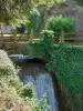
Visit the site of a medieval toll pass cut.


Favourite


| Municipality | Villers-sous-Chalamont |
|---|---|
| Postcode | 25270 |
| Latitude | 46.9038050 (N 46° 54’ 14”) |
| Longitude | 6.0423590 (E 6° 2’ 32”) |
| Altitude | From 658m to 901m |
| Surface area | 22.18 km² |
| Population | 311 inhabitants |
| Density | 14 inhabitants/km² |
| Prefecture | Besançon (60 km, 1:03) |
| Insee code | 25627 |
| Intercommunality | CC Altitude 800 |
| Department | Doubs |
| Territories | Franche-Comté, Jura mountains |
| Region | Burgundy-Franche-Comté |
| Arc-sous-Montenot | 4 km (7 min) |
|---|---|
| Villeneuve-d'Amont | 5.2 km (12 min) |
| Boujailles | 5.4 km (9 min) |
| Lemuy | 6.9 km (13 min) |
| Dournon | 8 km (13 min) |
| Levier | 8.8 km (11 min) |
| Courvières | 8.9 km (13 min) |
| Abergement-lès-Thésy | 9.9 km (15 min) |
| Montmarlon | 10.5 km (20 min) |
| Sainte-Anne | 11 km (17 min) |
| Crouzet-Migette | 11.1 km (17 min) |
| Thésy | 11.5 km (17 min) |
| Gevresin | 12.2 km (18 min) |
| Cuvier | 13 km (18 min) |
Visit the site of a medieval toll pass cut.
| Monuments |
|---|
| Last name | Activity type | Rate | City |
|---|---|---|---|
 | Sports sensations | 50 € | Foncine-le-Bas (29 km) |
 | Sports sensations | 38 € | Chapelle-des-Bois (34 km) |
 | Entertainment | 84 € to 110 € | Besançon (37 km) |
 | Sports sensations | 45 € to 55 € | Clairvaux-les-Lacs (43 km) |
 | Arts and Crafts | 70 € | Bletterans (48 km) |
| Last name | Outing type | Difficulty | Duration | Departure municipality |
|---|---|---|---|---|
 | Hike | Easy | 1:05 | La Rivière-Drugeon (13.8 km) |
 | Hike | Easy | 3:00 | Arbois (21 km) |
 | Hike | Easy | 1:45 | Poligny (27 km) |
 | Hike | Intermediate | 35 min | Hauterive-la-Fresse (33 km) |
| Hike | Easy | 1:00 | Lac-des-Rouges-Truites (34 km) |