Favourite
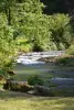
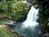
The Consolation rock formations
| Municipality | Vellevans |
|---|---|
| Postcode | 25430 |
| Latitude | 47.3112319 (N 47° 18’ 40”) |
| Longitude | 6.4972250 (E 6° 29’ 50”) |
| Altitude | From 392m to 733m |
| Surface area | 13.54 km² |
| Population | 240 inhabitants |
| Density | 17 inhabitants/km² |
| Prefecture | Besançon (43 km, 44 min) |
| Insee code | 25597 |
| Intercommunality | CC du Pays de Sancey-Belleherbe |
| Department | Doubs |
| Territories | Franche-Comté, Jura mountains |
| Region | Burgundy-Franche-Comté |
| Randevillers | 2.4 km (3 min) |
|---|---|
| Servin | 3 km (4 min) |
| Chazot | 4.7 km (8 min) |
| Lanans | 4.8 km (6 min) |
| Orve | 5.4 km (10 min) |
| Ouvans | 5.8 km (7 min) |
| Crosey-le-Petit | 7 km (10 min) |
| Vaudrivillers | 7.4 km (8 min) |
| Sancey | 7.9 km (10 min) |
| Crosey-le-Grand | 8 km (13 min) |
| Montivernage | 8.7 km (12 min) |
| Landresse | 8.8 km (12 min) |
| Cusance | 9.1 km (13 min) |
| Rahon | 10.7 km (11 min) |
| Natural sites |
|---|
| Last name | Activity type | Rate | City |
|---|---|---|---|
 | Entertainment | 84 € to 110 € | Besançon (37 km) |
| Last name | Outing type | Difficulty | Duration | Departure municipality |
|---|---|---|---|---|
 | Hike | Easy | 1:00 | Pays-de-Clerval (9.1 km) |
 | Hike | Intermediate | 35 min | Grand-Charmont (34 km) |
 | Hike | Easy | 6:00 | Devecey (36 km) |
 | Hike | Intermediate | 35 min | Hauterive-la-Fresse (38 km) |
 | Hike | Athletic | 5:05 | Fretigney-et-Velloreille (46 km) |