
Favourite
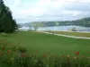
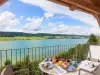
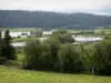
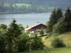
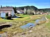
The Remoray lake


| Municipality | Vaux-et-Chantegrue |
|---|---|
| Postcode | 25160 |
| Latitude | 46.8107420 (N 46° 48’ 39”) |
| Longitude | 6.2508780 (E 6° 15’ 3”) |
| Altitude | From 858m to 1074m |
| Surface area | 13.98 km² |
| Population | 646 inhabitants |
| Density | 46 inhabitants/km² |
| Prefecture | Besançon (75 km, 1:10) |
| Insee code | 25592 |
| Intercommunality | CC du Plateau de Frasne et du Val du Drugeon |
| Department | Doubs |
| Territories | Franche-Comté, Jura mountains |
| Region | Burgundy-Franche-Comté |
| Malpas | 3.8 km (7 min) |
|---|---|
| La Planée | 4.2 km (11 min) |
| Labergement-Sainte-Marie | 6.4 km (8 min) |
| Bonnevaux | 7.3 km (8 min) |
| Malbuisson | 7.5 km (10 min) |
| Saint-Point-Lac | 7.9 km (10 min) |
| Remoray-Boujeons | 8.5 km (10 min) |
| Oye-et-Pallet | 8.7 km (14 min) |
| Les Grangettes | 9.9 km (13 min) |
| Saint-Antoine | 9.9 km (12 min) |
| Brey-et-Maison-du-Bois | 10.7 km (12 min) |
| Métabief | 11.1 km (13 min) |
| Rochejean | 11.2 km (15 min) |
| Sainte-Colombe | 11.6 km (22 min) |
| Natural sites |
|---|
| Last name | Activity type | Rate | City |
|---|---|---|---|
 | Sports sensations | 38 € | Chapelle-des-Bois (25 km) |
 | Sports sensations | 50 € | Foncine-le-Bas (25 km) |
 | Sports sensations | 45 € to 55 € | Clairvaux-les-Lacs (46 km) |
| Last name | Outing type | Difficulty | Duration | Departure municipality |
|---|---|---|---|---|
 | Hike | Easy | 1:05 | La Rivière-Drugeon (6.7 km) |
 | Hike | Intermediate | 35 min | Hauterive-la-Fresse (24 km) |
 | Hike | Easy | 1:00 | Lac-des-Rouges-Truites (30 km) |
| Hike | Athletic | 3:30 | Bellefontaine (32 km) |
| Hike | Easy | 3:00 | Arbois (38 km) |