Liven up your holidays!

Valmeinier

Tourism, holidays & weekends guide in the Savoie

Valmeinier - Tourism, holidays & weekends guide in the Savoie
7.1
3

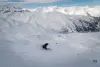
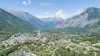
Valmeinier station and village in the south of Savoy in the heart of the Maurienne and nestled on the ski area "Galibier Thabor."

At the gates of Italy, nestled in the heart of the World Heritage Site of Mont Thabo real "weather control tower" between the Southern Alps and the Northern Alps, Valmeinier offers exceptional both for its natural protected area by the rational architecture.

It reached its heights from the city of Saint-Michel-de-Maurienne (17 km).

Valmeinier, "val-mining", perhaps because of the presence of copper and silver ore lead operated locally by hand in the 18th century as a result of the presence of vein of anthracite operated mainly on the family plan for domestic heating.

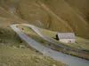
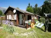
Valmeinier, Valley Neuvache, steep slopes whose land was retained by terraces still visible in winter terraces for the cultivation of cereals (especially rye), but also beans, turnips and potatoes ... from the 18th century; cones droppings with their stream where the villages are born with wooden houses and stone, interlocking others to leave more room for crops, pastures at altitudes between 1300 and 1800 m, up to 2500 m for the summer transhumance. Here, then, almost immutable from the 12th to the 20th century difficult agro-pastoral life, the rhythm of the seasons, set by religious practices, as evidenced by the crosses planted here and there, the district chapels church several times rebuilt.

However, despite the epidemics (plague in the 17th century), the wars, the bag Valmeinier by the French Revolution in 1793, years of poor harvest, the population increases, reaching its maximum (850 inhabitants) in 1848.

From there, with the industrialization began the decline. Bi-active for a few years (mine or factory and field work), men become factory workers and leave the mountain to settle in their workplace. Valmeinier and dying little by little, more cash than fifty permanent residents in 1971 with the closure of the last of its five schools in 1972.

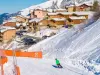
That's when a new team comes ahead of the common and chooses the tourism development Valmeinier 1500, with the equipment operating Cret Quarter winter 73/74, followed by equipment capital ( between the two cities) 1984-85-86 with two holiday centers, co-properties, commercial premises, a new school, Transvaal to connect the two sides of the valley, the chairlift Roy.

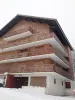
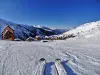
In 1986 began the third phase of tourism development Valmeinier with the construction of the road, lifts and accommodation in early 1800 Valmeinier 1800 that would cease to equip and improve its reception capacity .. . in this context largely open landscapes to discover.

Geographical information

MunicipalityValmeinier
Postcode73450
Latitude45.1834140 (N 45° 11’ 0”)
Longitude6.4786240 (E 6° 28’ 43”)
AltitudeFrom 1200m to 3160m
Surface area54.26 km²
Population572 inhabitants
Density10 inhabitants/km²
PrefectureChambéry (99 km, 1:11)
Insee code73307
IntercommunalityCC Maurienne Galibier
DepartmentSavoie
TerritoryAlps
RegionAuvergne-Rhône-Alps

Nearest cities & towns

Saint-Martin-d'Arc10.7 km (18 min)
Valloire10.8 km (16 min)
Saint-Michel-de-Maurienne12 km (22 min)
Saint-Martin-de-la-Porte14.8 km (28 min)
Orelle17.4 km (27 min)
Saint-Julien-Mont-Denis19.5 km (27 min)
Montricher-Albanne21 km (33 min)
Villargondran24 km (36 min)
Freney25 km (33 min)
Saint-Jean-de-Maurienne25 km (32 min)
Saint-André26 km (33 min)
Fourneaux26 km (33 min)
La Tour-en-Maurienne27 km (33 min)
Les Karellis27 km (52 min)

Things to see and do

Winter activities: Snowshoeing - Snakegliss - Dog sledding - ULM - Paragliding.

Summer activities: Guided walks - Archery - Cani hiking - Ruisseling - Tennis - Swimming pool.

The inhabitants of Valmeinier (valmineux and valmineuses) remain very attached to their history, their tradition and their environment. Each meeting, each site is an invitation to discover: local gastronomy (tartiflette, croziflette, blueberry tart, cheese, etc.), including built heritage (church, chapels, mill, etc.), crafts and encounter with animals.

The volunteers of the association for the preservation and enhancement of the heritage of Valmeinier also enrich holidaymakers with all kinds of anecdotes about their country, offer free guided tours of the church.

The farm of Mont Thabor: a friendly and passionate young couple shares with you their love for animals. You have the opportunity to discover in a typical setting goats and kids, yaks and rabbits as well as the transformation of goat's milk into cheeses of all kinds. The whole family will have a blast!

Places of interest

Leisure centres
Natural sites

Events and festivities

Valmeinier Obstacle Race

Photos

Valmeinier 1800
Valmeinier 1800
See photo
Valmeinier 1800
Valmeinier 1800
See photo
Nature nearby
Nature nearby
See photo
Valmeinier 1500
Valmeinier 1500
See photo
Valmeinier 1500
Valmeinier 1500
See photo
Nature nearby
Nature nearby
See photo
Nature nearby
Nature nearby
See photo
Nature nearby
Nature nearby
See photo
Valmeinier 1800
Valmeinier 1800
See photo
Nature nearby
Nature nearby
See photo

Weather

Thursday 25 april
Min. -10°C - Max. 6°C
Day
Night
Friday 26 april
Min. -5°C - Max. -1°C
Day
Night
Saturday 27 april
Min. -3°C - Max. 0°C
Day
Night

Visits, leisure and activities nearby

Leisure activities

Last nameActivity typeRateCity
Tailor-made photo shoot
Arts and Crafts120 € to 190 € Villarembert (17.1 km)
Refuges Sentinelles long-distance science hike
Culture and education585 € Villar-d'Arêne (19.2 km)
Guided hike in Haute Maurienne Vanoise
Nature and the great outdoors15 € to 230 € Val-Cenis (24 km)
Fly fishing in Hautes-Alpes
Nature and the great outdoors150 € to 220 € Saint-Martin-de-Queyrières (39 km)
Family rafting course in the Isère gorges
Sports sensations62 € Aime-la-Plagne (40 km)

Outings

Last nameOuting typeDifficultyDurationDeparture municipality
Valloirette Fitness Trail
HikeEasy2:00Valloire (4.4 km)
Poingt Ravier Eco-Forest Trail
HikeEasy2:30Valloire (4.6 km)
Lakes and Snake Laramon
HikeIntermediate3:30Névache (21 km)
Long and Round lakes
HikeIntermediate4:30Névache (21 km)
Trekking from Aussois Dams to Parrachée Dent Hut
HikeEasy2:30Aussois (21 km)

Restaurants

Bed & breakfasts

Vacation rentals

Campsites

Hotels

Your holidays
A hotel
A vacation rental
A bed & breakfast
A campsite
A leisure activity
A restaurant
A rental car
A plane ticket
By continuing to browse our site, you are agreeing to the use of cookies to improve your experience and make targeted offers.
Find out more and make settings
Your account