Favourite
Annot
| Municipality | Ubraye |
|---|---|
| Postcode | 04240 |
| Latitude | 43.9088390 (N 43° 54’ 32”) |
| Longitude | 6.6966580 (E 6° 41’ 48”) |
| Altitude | From 720m to 1938m |
| Surface area | 35.65 km² |
| Population | 101 inhabitants |
| Density | 2 inhabitants/km² |
| Prefecture | Digne-les-Bains (68 km, 1:05) |
| Insee code | 04224 |
| Intercommunality | CC Alpes-Provence-Verdon - Sources de Lumière |
| Department | Alpes-de-Haute-Provence |
| Territories | Alps, Provence |
| Region | Provence-Alps-French Riviera |
| Annot | 11.9 km (18 min) |
|---|---|
| Val-de-Chalvagne | 13.2 km (21 min) |
| Vergons | 14.5 km (19 min) |
| Saint-Benoît | 15.1 km (24 min) |
| Le Fugeret | 16.9 km (25 min) |
| Braux | 17.5 km (26 min) |
| Briançonnet | 18.4 km (28 min) |
| Saint-Julien-du-Verdon | 18.7 km (24 min) |
| Soleilhas | 18.7 km (42 min) |
| Méailles | 19.6 km (28 min) |
| Castellet-lès-Sausses | 21 km (30 min) |
| Entrevaux | 22 km (25 min) |
| Sausses | 22 km (29 min) |
| Angles | 24 km (31 min) |
| Last name | Activity type | Rate | City |
|---|---|---|---|
 | Sports sensations | 45 € to 85 € | Castellane (16.4 km) |
 | Sports sensations | 50 € to 85 € | Castellane (16.6 km) |
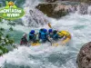 | Sports sensations | 45 € to 85 € | Castellane (16.7 km) |
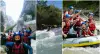 | Sports sensations | 35 € | Puget-Théniers (16.8 km) |
 | Nature and the great outdoors | 50 € to 80 € | Castellane (23 km) |
| Last name | Outing type | Difficulty | Duration | Departure municipality |
|---|---|---|---|---|
 | Hike | Easy | 2:30 | Annot (6.8 km) |
 | Hike | Intermediate | 3:30 | Thorenc (14.4 km) |
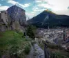 | Village visit | Easy | 1:15 | Castellane (16.2 km) |
 | Hike | Athletic | 5:00 | Gréolières (23 km) |
 | Hike | Easy | 2:45 | Gréolières (23 km) |