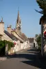
Saint-Mars benefits from its strategic position. Thus, the town is crossed by the road to Paris which probably promotes and energizes industrial activity.
Saint-Mars-la-Brière, deformation of Saint-Mars-la-Bruyère, was added by the decree of November 13, 1809, the hamlet of Saint-Denis-du-Tertre. The discovery of fragments of Roman glass in the excavation of the railway line attests to the presence of a population in Saint-Mars from that time.
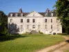
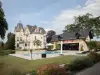
The seigneury of the parish is annexed to the Château de Saint-Mars. This one, whose origins date back to medieval times, is owned by powerful families: it belongs, in the 16th century, to the Laval-Boisdauphin house and, in the 18th century, to the Bailly
®2 family. ® Populated by approximately 2,717 inhabitants known as the Briérois (e) s. The 2020 census survey counted 2717 inhabitants or a density of 72hab / km², a population which has been increasing continuously since 1940 and with an area of 34.69km².
Located 15 km from Le Mans, it is made up of 4 parts: the town center, the hamlet of Chesnaie, the hamlet of Loudonneaux and the hamlet of Saint Denis du Tertre.
Crossing from West to East by the D323 linking Nantes to Paris, the D357 linking Blois-Rennes, the Paris-Brest railway line and the Océane A11 motorway, the town is a crossroads in the great West.
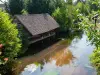
It is watered from east to west by the Huisne and crossed by a small fishing stream: The Narais, whose course winds from south to north-northeast and will merge towards Huisne in downstream of the Bourray paper mills.
The town is served by a station on the Paris Montparnasse-Brest line and the Sarthe interurban transport network: the TIS.
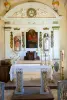
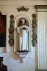
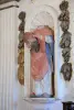
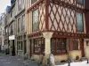
THE city has a rich heritage of historical monuments such as the Saint-Denis chapel, the Saint-Médard church, the prehistoric station located on the Auvours military camps.
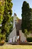
The Saint-Denis-du-Tertre chapel: 11th and 12th centuries. This modest chapel surrounded by a small cemetery is located 3 km from the center of Saint-Mars-la-Brière, on top of a hill. Paintings on wood adorn the vault of the chapel (around the 11th century). On the west gable of the chapel stands an elegant 11th century bell tower, in a campanile, with two semicircular openings. One of the bells dates from 1875.
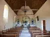
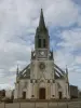
The Saint-Médard church: from the 16th century, with semi-pointed openings and steeple.
The prehistoric station located on the Auvours camp at Saint-Mars-la-Brière: Discovered in 1968 by Roger Guyot, it is installed on a sandy plateau overlooking the Narais valley. It is made up of a set of habitats. One of these was studied in an exemplary way by Mr. Allard, from 1970. His excavations revealed remarkable dry stone structures delimiting a roughly square hut bottom and partially partitioning it. The mainly lithic archaeological material abounds inside the habitat. The tools are characterized by a profusion of lamellae, microlithic points, chisels, scrapers… relating to a purely Paleolithic way of life, based on hunting (age close to 4600 years BC).
Consult the website of the Town Hall of Saint-Mars-la-Brière for the "discovery booklet of Saint-Mars-la-Brière" published by the Pays d'Art et d'Histoire du Perche Sarthois.
Trails and discovery: Many communal paths crisscross the town and allow you to travel it on foot or by bike.
- The Perche Sarthois hiking guide: Le Perche Sarthois has selected 46 hiking trails based on precise criteria. This is to ensure quality routes, maintained and correctly marked. 6 new circuits identified in the municipalities of Bessé-sur-Braye, Boessé-le-Sec, Courcemont, Sillé-le-Philippe, Surfonds, Saint-Gervais-de-Vic and La Chapelle-Huon. In this edition, which has 46 circuits, pictograms have been integrated to allow hikers to easily identify and locate points of interest and the various services on each of the
circuits over the 600 kilometers of trails, wander through the green valleys and wooded hills that have made the reputation of the Sarthois perch, a region where life and hiking are good. Sale price: € 6. The hiking guide is available from the Perche Sarthois tourist offices in La Ferté-Bernard, Bonnétable, Vibraye and Saint-Calais and soon from the various Sarthois perch providers and Sarthois partners. More information on +33 2 43 60 72 77 / tourisme-perchesarthois@orange.fr
- Le Perche Sarthois by bike: Presented in the form of a pocket, this guide is made up of 10 individual flyers corresponding to the 10 marked loops, with nearly 500 kilometers of routes. Connected to each other, to the Sarthe by bike and to the Loir valley by bike, the Perche Sarthois bike loops allow, thanks to the variations, shortcuts and intercircuit links, to realize your itinerary à la carte. Sale price: € 3.