
Favourite
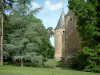
Meillant Castle
| Municipality | Saint-Loup-des-Chaumes |
|---|---|
| Postcode | 18190 |
| Latitude | 46.8233370 (N 46° 49’ 24”) |
| Longitude | 2.3880940 (E 2° 23’ 17”) |
| Altitude | From 133m to 177m |
| Surface area | 18.55 km² |
| Population | 300 inhabitants |
| Density | 16 inhabitants/km² |
| Prefecture | Bourges (31 km, 33 min) |
| Insee code | 18221 |
| Intercommunality | CC Arnon Boischaut Cher |
| Department | Cher |
| Territory | Berry |
| Region | Centre-Loire Valley |
| Chavannes | 4.2 km (6 min) |
|---|---|
| Crézançay-sur-Cher | 4.7 km (8 min) |
| Vallenay | 5.1 km (7 min) |
| Uzay-le-Venon | 5.8 km (9 min) |
| Bruère-Allichamps | 8.3 km (9 min) |
| Serruelles | 8.7 km (12 min) |
| Châteauneuf-sur-Cher | 8.7 km (10 min) |
| Saint-Symphorien | 8.9 km (16 min) |
| La Celle | 9.1 km (10 min) |
| Venesmes | 9.9 km (15 min) |
| Contres | 10.2 km (9 min) |
| Farges-Allichamps | 11.2 km (13 min) |
| Levet | 12.1 km (10 min) |
| Chambon | 12.8 km (16 min) |
| Last name | Activity type | Rate | City |
|---|---|---|---|
 | Entertainment | 75 € to 120 € | Issoudun (33 km) |
 | Culture and education | Free | Germigny-l'Exempt (40 km) |
| Last name | Outing type | Difficulty | Duration | Departure municipality |
|---|---|---|---|---|
 | Hike | Easy | 2:00 | Quincy (39 km) |
 | Village visit | Easy | 1:00 | Hérisson (43 km) |
 | Hike | Easy | 3:00 | Moutier-Malcard (59 km) |