
Favourite
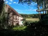
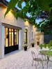
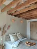
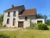
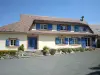
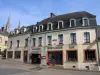
Mortagne-au-Perche
| Municipality | Saint-Hilaire-le-Châtel |
|---|---|
| Postcode | 61400 |
| Latitude | 48.5637710 (N 48° 33’ 50”) |
| Longitude | 0.5287980 (E 0° 31’ 44”) |
| Altitude | From 167m to 294m |
| Surface area | 22.34 km² |
| Population | 666 inhabitants |
| Density | 29 inhabitants/km² |
| Prefecture | Alençon (42 km, 36 min) |
| Insee code | 61404 |
| Intercommunality | CC du Pays de Mortagne au Perche |
| Department | Orne |
| Territory | Perche |
| Region | Normandy |
| Sainte-Céronne-lès-Mortagne | 1 km (3 min) |
|---|---|
| Soligny-la-Trappe | 6.5 km (11 min) |
| Villiers-sous-Mortagne | 6.5 km (12 min) |
| Mortagne-au-Perche | 6.5 km (10 min) |
| Saint-Ouen-de-Sécherouvre | 7.7 km (11 min) |
| Saint-Langis-lès-Mortagne | 7.9 km (12 min) |
| Courgeoût | 8.4 km (11 min) |
| Saint-Germain-de-Martigny | 8.4 km (12 min) |
| Bazoches-sur-Hoëne | 8.9 km (11 min) |
| Champeaux-sur-Sarthe | 9.6 km (15 min) |
| Boëcé | 10.4 km (12 min) |
| Bonsmoulins | 10.5 km (18 min) |
| Saint-Aubin-de-Courteraie | 10.9 km (15 min) |
| Feings | 10.9 km (15 min) |
| Last name | Activity type | Rate | City |
|---|---|---|---|
 | Sports sensations | 22 € to 75 € | Fontaine-Simon (37 km) |
| Last name | Outing type | Difficulty | Duration | Departure municipality |
|---|---|---|---|---|
 | Hike | Easy | 3:25 | Saint-Longis (27 km) |
 | Hike | Easy | 3:45 | Jauzé (41 km) |
 | Hike | Easy | 55 min | Bonnétable (44 km) |
 | Hike | Intermediate | 2:45 | Nonvilliers-Grandhoux (53 km) |